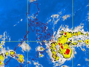
Tropical Storm ‘Sendong’ to hit Visayas, Mindanao Friday
Tropical depression “Sendong” (international name: Washi) intensified into a tropical storm over the Philippine Sea Thursday afternoon, threatening to dump heavy rains over northeastern Mindanao and eastern Visayas Friday and over the weekend.
Packing maximum sustained winds of 65 kilometers per hour with gusts of up to 80 kph, Sendong was forecast to make landfall in Tandag, Surigao del Sur, at mid-afternoon on Friday, the Philippine Atmospheric, Geophysical and Astronomical Services Administration (Pagasa) said.
The weather bureau raised Storm Signal No. 2 over Eastern Samar, Western Samar, Leyte Provinces, Camotes Island, Bohol, Surigao Del Norte including Siargao Island, Surigao Del Sur and Dinagat Province, Agusan Provinces and Misamis Oriental.
Meanwhile, Storm Signal No. 1 was hoisted over Sorsogon, Ticao Island, Masbate, Northern Samar, Biliran Island,Panay Island, Guimaras, Negros Provinces, Cebu, Siquijor Island, Davao Oriental, Daval Del Norte, Samal Island, Bukidnon, Lanao Provinces, Misamis Occidental and
Zamboanga Provinces.
Article continues after this advertisement19th this year
Article continues after this advertisementThe storm, the 19th cyclone to swirl into the Philippine area of responsibility this year, would spawn 10-25 millimeters of rainfall, or heavy rain, and gusty winds in those areas, Pagasa said.
“We expect winds of 45 to 60 kph in at least 36 hours. We have a lead time of 36 hours,” forecaster Raymond Ordinario told reporters Thursday afternoon.
Rain would fall in northeastern Mindanao on Thursday night, and in eastern Visayas and parts of eastern Mindanao and southern Luzon on Friday morning, becoming heavy later that night, Ordinario said.
“Residents along riverbanks, dry riverbeds and other low-lying areas must heed warnings issued by their local authorities. With the projected rain from the storm, people on mountain slopes are advised to observe extreme caution,” he said.
Flash floods and landslides could occur, he added.
In Metro Manila, the storm is expected to enhance the northwest monsoon (amihan) and bring moderate to heavy rain over the metropolis and the rest of Luzon over the weekend, Pagasa said. It warned against sea travel in the western seaboards of Luzon and the Visayas.
‘Simbang Gabi’ spoiler
The rains threaten to spoil the “Simbang Gabi,” the Catholic nine-day dawn Masses leading up to Christmas Day, which begin Friday.
Sendong could still intensify over water, but is expected to weaken after making landfall, Pagasa said.
It is on track to traverse the Visayas and exit in northern Palawan over the West Philippine Sea (South China Sea) by Sunday night or Monday morning.
As of 10 p.m. on Thursday, its center was spotted at 430 km east southeast of Hinatuan, Surigao del Sur. As it swirled west northwest at 30 kph, it was forecast to be 100 km east northeast of Puerto Princesa City by Saturday evening.
In Bicol, the Regional Disaster Risk Reduction and Management Council warned against flooding in five provinces due to Sendong.
“People living near the mountain slopes and [waterways of Camarines Norte, Camarines Sur, Catanduanes, Albay and Sorsogon] and the local disaster risk reduction and management councils are advised to be alert for possible flash floods and landslides,” said Bernardo Alejandro, regional director of the Office of Civil Defense and disaster management head in Bicol.
In Albay, the Provincial Disaster Risk Reduction and Management Council was monitoring the situation in the entire province.
Rice stocks were being repacked since Wednesday to feed residents who may need to be evacuated from their homes. With a report from Rey M. Nasol, Inquirer Southern Luzon
