DPWH readies heavy equipment, service vehicles in Albay for Mayon eruption
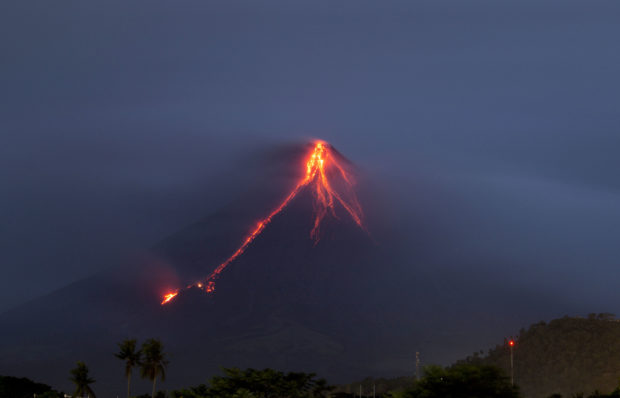
Lava continues to cascade down the slopes of Mayon volcano as seen from Legazpi city, Albay province, around 340 kilometers (210 miles) southeast of Manila, Philippines, at dawn Tuesday, Jan. 16, 2018. Glowing red lava was rolling down the slopes of a Philippine volcano as authorities maintain a warning of a possible hazardous eruption. (AP Photo/Earl Recamunda)
The Department of Public Works and Highways (DPWH) is closely monitoring road networks and river channels in Albay as it prepares for the threat of a hazardous eruption of Mayon Volcano.
The agency has also pre-positioned heavy equipment and service vehicles to aid in road clearing operations, the evacuation of residents, and the delivery of relief goods.
Danilo Versola, DPWH director for the Bicol region, has ordered three DPWH district engineering offices to keep a close eye on roads and rivers that may be affected by lava from the volcano.
“In a worst-case scenario, we identified alternate routes to prevent the isolation of municipalities highly vulnerable to ash plume and volcanic mudflows or lahar,” he said in a statement.
Earlier, the Philippine Institute of Volcanology and Seismology (Phivolcs) warned of a possible hazardous eruption within days or weeks from the volcano.
Article continues after this advertisementA hazardous or explosive eruption is defined as a lava fountain or a spray of hot rocks and gases that could move as fast as 60 kilometers per hour.
Article continues after this advertisementThe volcano first spewed ash and rocks over the weekend, followed by lava and ash on Monday night, prompting more than 12,000 residents to flee their homes.
The DPWH said the Tabaco-Ligao National Secondary Road would be the alternate route if the Legazpi-Sto Domingo-Tabaco Road is affected from lahar or ashfall on the southeast part of the volcano.
Vehicles traveling from Manila to Legazpi City and Sorsogon can take the Camalig-Comun-Gapo-Peñafrancia National Secondary Road if the Camalig Section of Daang Maharlika Highway on the south of the volcano is affected.
If volcanic ash reaches Guinobatan, the Ligao-Tabaco Road can be an alternative road to reach the Guinobatan Section of the Daang Maharlika Highway.
RELATED VIDEO