
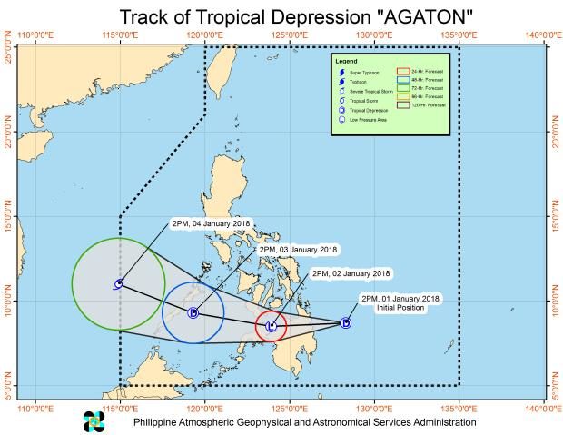
Track of Tropical Depression “Agaton” as of 5 p.m. Monday, Jan. 1, 2018.
A low pressure area (LPA) spotted east-southeast of Surigao City has developed into a tropical depression named “Agaton,” which will continue to dump rains in the Visayas and Mindanao, the state weather bureau said Monday.
Agaton will bring heavy rains with gusty winds in the regions of Bicol, Eastern Visayas, Caraga, Davao, according to the 5 p.m. briefing broadcast online by the Philippine Atmospheric, Geophysical and Astronomical Services Administration (Pagasa).
Storm Signal no. 1 has been raised over the following areas:
- Surigao del Norte including Siargao Island
- Surigao del Sur
- Dinagat Island
- Agusan del Norte
- Agusan del Sur
- Davao Oriental
- Davao del Norte
- Davao del Sur
- North Cotabato
- Compostela Valley
- Misamis Oriental
- Misamis Occidental
- Lanao del Norte
- Lanao del Sur
- Camiguin
- Bukidnon
Sea travel is risky in these areas, as well as the seaboards of Northern Luzon and Southern Luzon, the eastern seaboard of Central Luzon, and the eastern and western seaboards of the Visayas due to the surge of the northeast monsoon.
Agaton has maximum sustained winds of 45 kph near the center and gustiness of up to 60 kph. It is forecast to be moving west at a speed of 19 kph.
As of 4 p.m., Agaton was located 175 kilometers east northeast of Hinatuan in Surigao del Sur and is expected to reach east of Dipolog City in Zamboanga del Norte by Tuesday afternoon, Pagasa said.
The tail-end of a cold front will strengthen the trough of Agaton.
Pagasa urged the public to cooperate with their local disaster and risk reduction teams as possible flashfloods or landslides might occur in these areas due to widespread moderate to occasional heavy rains.
The agency took note that resident in localities damaged by tropical storm Vinta should take extra care as soil in these areas were still wet and more prone to landslides and flashfloods.
Agaton will likely weaken to an LPA once making landfall in Caraga and again intensify into a tropical depression once it reaches the Sulu Sea. /atm