Signal No. 1 up over 15 areas in Luzon as 2 weather disturbances enter PAR
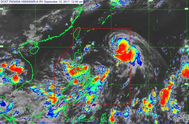
Pagasa satellite image shows Typhoon “Lannie” (red spot, upper right) and Tropical Depression “Maring” (red spot, center over Luzon)
Two weather disturbances have entered the Philippine area of responsibility – Typhoon “Lannie” and Tropical Depression “Maring.”
This is according to the bulletins issued at 11 p.m. on Monday by the Philippine Atmospheric, Geophysical and Astronomical Services Administration (Pagasa).
Pagasa forecaster Aldczar Aurelio noted that 2009 was the last time the country had two weather disturbances – Pepeng, which entered PAR on Sept. 30, and Quedan, which entered PAR on Oct. 5.
As of 11 p.m. on Monday, Pagasa had raised Signal No. 1 over 15 areas in Luzon:
- Metro Manila
- Pangasinan
- Quirino
- Zambales
- Bataan
- Aurora
- Tarlac
- Pampanga
- Nueva Ecija
- Bulacan
- Rizal
- Northern Quezon, including Polillo Island
- Catanduanes
- Camarines Norte
- Camarines Sur
“Lannie” was expected to bring moderate to occasionally heavy rains with its 350-km diameter.
Article continues after this advertisementOn the other hand, “Maring” was expected to bring moderate to occasionally heavy rains over the Pangasinan province and the regions of Bicol, Calabarzon, Mimaropa, Metro Manila, and Central Luzon.
Article continues after this advertisementAs of 10 p.m., the eye of the Typhoon “Lannie” was located at 1,255 km east of Aparri, Cagayan. The typhoon had maximum sustained winds of 120 kph near the center, with a gustiness reaching up to 145 kph.
“Lannie” was moving west-northwest at 26 kph and was expected to move out of PAR by Thursday evening.
Also as of 10 p.m., the center of Tropical Depression “Maring” was locate at 190 km east of Infanta, Quezon. It had maximum winds of 45 kph near the center, with a gustiness reaching up to 60 kph.
“Maring” was moving west-northwest at 13 kph and was expected to make landfall in the Quezon-Aurora area on Tuesday and to move out of PAR by Friday evening.
/atm