
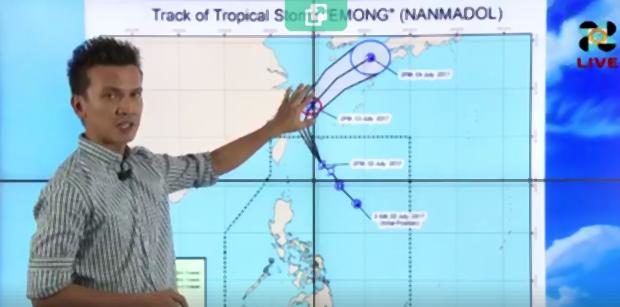
Pagasa forecaster Aldczar Aurelio shows the track of tropical storm Emong in Pagasa’s 5:00 p.m. forecast on Sunday, July 2, 2017. (Photo from a Pagasa video posted on Facebook)
First published 4:51 p.m., July 2, 2017
A tropical storm was spotted near Basco, Batanes on Sunday as it headed northward outside the Philippine Area of Responsibility (PAR) toward Ryukyu Islands, according to the Philippine Atmospheric, Geophysical and Astronomical Services Administration (Pagasa).
In a 5:00 p.m. live weather forecast, Pagasa forecaster Aldczar Aurelio said the eye of Emong (international name: Nanmadol) was spotted at 405 kilometers northeast of Basco, Batanes.
The storm has maximum sustained winds of 85 kilometers per hour (kph) near the center and gustiness of up to 95 kph.
Aurelio said the storm was moving northwest, away from the country, at 30 kph, and it should be outside PAR by Monday afternoon.
Cloudy skies would prevail over Palawan, the Zamboanga Peninsula, and the Autonomous Region in Muslim Mindanao (ARMM). These areas could expect light to moderate rains.
The rest of the country, including Metro Manila, would have partly cloudy to cloudy skies and could expect isolated thunderstorms in the afternoon or early evening.
Pagasa declared no storm signals. – /JE /atm