
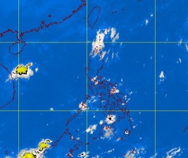
MTSAT ENHANCED IR Satellite Image
MANILA, Philippines—Wednesday morning’s rains in Metro Manila were caused not by an incoming low pressure area, but the convergence of winds, forecasters of the Philippine Atmospheric Geophysical and Astronomical Services Administration said.
“This is a result of the convergence of northeast and east winds,’’ Pagasa forecaster Raymond Ordinario said by phone, referring to the wind convergence affecting the eastern sections of Northern and Central Luzon.
A shallow low pressure area that has formed over the Philippine Sea east of Mindanao, and was 200 kilometers east northeast of Davao City at around 8 a.m. Wednesday was unlikely to develop into a tropical cyclone, Ordinario said.
By Wednesday afternoon, forecasters were checking if the LPA had interacted with land, and if that were so, this would likely dissipate soon, he said.
The LPA was embedded along the Intertropical Convergence Zone, affecting Southern Luzon, Visayas and Mindanao.
Because of the ITCZ, Eastern and Southern Luzon, Visayas and Mindanao would experience mostly cloudy skies with scattered rainshowers and thunderstorms, Pagasa said.
These would become cloudy with widespread rains over Aurora, Quezon, Bicol Region, Eastern Visayas and Eastern Mindanao that may trigger flashfloods and landslides. The rest of the country will be partly cloudy to cloudy with isolated rainshowers or thunderstorms.
Pagasa advised residents of the coastal areas of Northern and Central Luzon against setting out to sea due to big waves generated by the strong northeasterly winds.
Pagasa, however, was also monitoring another LPA still swirling over the Pacific Ocean outside of the Philippine area of responsibility.