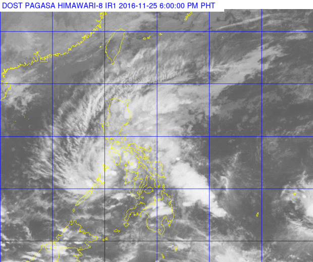
‘Marce’ to make 5th landfall over Calamian Island
Tropical Storm “Marce” (international name: Tokage) maintained its strength as it neared landfall over the Calamian group of islands, the state weather bureau said on Friday afternoon.
The storm packed maximum sustained winds of up to 65 kilometers per hour near the center and gusts of up to 100 kph, the Philippine Atmospheric, Geophysical and Astronomical Services Administration said.
Signal No. 2 was raised over the Calamian group of islands, Cuyo Island, southern Occidental Mindoro and southern Oriental Mindoro.
The storm was expected to hit the Calamian islands between 5 and 6 p.m.
The rest of Occidental Mindoro and Oriental Mindoro, northern Palawan and Romblon, Aklan and Antique were placed under Signal No. 1.
Article continues after this advertisementTropical cyclone warnings elsewhere were already lifted, Pagasa said.
Article continues after this advertisementResidents of areas under storm signals, as well as the Bicol region and the province of Aurora and Quezon, were warned of possible flashfloods and landslides.
Pagasa also warned against sea travel over the northern and eastern seaboards of northern Luzon and the seaboards of central and southern Luzon.
The storm has made four landfalls since Thursday afternoon—in Siargao Island; Abuyog, Leyte; Daanbantayan in Cebu, and Carles, Iloilo.
Marce was last spotted 55 kilometers southeast of Coron, Palawan, moving west northwest at 22 kph. It is expected to exit the Philippine area of responsibility by Sunday before noon or in the afternoon.
Moderate to heavy rains are expected within its 300-kilometer radius.
“Stormy weather will be experienced over southern Occidental Mindoro, southern Oriental Mindoro and Calamian group of islands, with rough to very rough seas,” Pagasa said
Rains with gusty winds, meanwhile, will prevail over the rest of Mindoro provinces, northern Palawan, Romblon, Antique at Aklan.
Quezon, Aurora and the Bicol region will have cloudy skies with moderate to occasionally heavy rains and thunderstorms which may trigger flashfloods and landslides./rga
