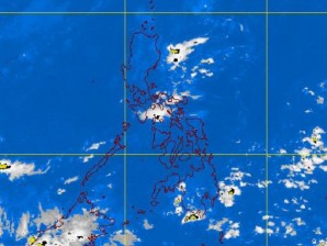
MANILA, Philippines—No stormy weather is likely to disrupt the long weekend and the observance of All Souls and All Saints Days, the state weather agency said on Friday.
The Philippine Atmospheric, Geophysical, Astronomical Services Administration (Pagasa) said the country’s skies will be mostly clear in the next five days.
As of Friday, no typhoon was seen in the Pacific, Robert Sawi, Pagasa’s chief weather forecaster, said in a press briefing Friday.
According to Sawi, the daytime “will be warm and humid with isolated rain showers and thunderstorms in the afternoon or evening.”
The weather bureau also noted that cooler temperatures could be felt in northern and central Luzon as the northeast monsoon (Amihan) becomes the dominant weather system in the country.
The northeast monsoon is characterized by a cold and relatively drier weather condition. The season is expected to last until the first half of March next year, although breaks are expected.
Although no typhoons are in sight, Filipinos should still be prepared for downpours in the days ahead, Pagasa said in its advisory.
Eastern Luzon might experience light rains starting Saturday until Nov. 2 due to the convergence of the northeasterly and easterly winds, the advisory said.
Downpours may occur in the Visayas and Mindanao on Oct. 29 due to a low pressure area that could embed in the Intertropical Convergence Zone, Pagasa said.
The rains are expected to spread in the eastern section of the country on Nov. 1 and 2.
Meanwhile, Sawi said the country should brace for two or three more typhoons before 2011 closes.
Sawi said the country could see cyclones in November. The agency expects one typhoon in December.
The Philippines is visited by an average of 19 typhoons every year. So far, 18 typhoons have entered the country’s area of responsibility.
Pagasa also noted that rainy weather might be experienced by the coastal provinces in the eastern seaboard due to a weak La Niña phenomenon.
Because of this weather phenomenon, characterized by a drop in the surface temperature of the ocean, the eastern sections could experience near to above normal rainfall conditions until the first quarter of 2012, Pagasa said.
The La Niña usually brings above-average rainfall in the country. It started on the 3rd quarter of year 2010 and ebbed in May 2011. Since August, however, weathermen have again been noticing cooler temperatures in the Pacific, indicating the possibility of a La Niña resurgence.
