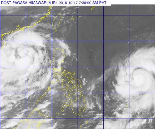
The Philippines sits in the middle of two typhoons as Typhoon ‘Karen’ (left) swirls away from the country and Typhoon ‘Haima’ crawls closer on the lower right. Haima is forecast to enter the Philippine area of responsibility Monday afternoon or evening. PAGASA PHOTO
All storm signals were lifted early Monday after Typhoon “Karen” (international name Sarika) left the Philippine area of responsibility (PAR) as a new typhoon approaches.
Karen was 565 kilometers west of Dagupan, Pangasinan, as of 2 a.m., moving west northwest at 22 kilometers per hour, the Philippine Atmospheric, Geophysical and Astronomical Services Administration (Pagasa) said.
Despite Karen’s exit, fisherfolk and seafarers in small seacraft are advised not to venture out over the northern and western seaboards of northern Luzon and the western seaboard of Central Luzon, Pagasa said.
Meanwhile, Typhoon “Haima,” which will be locally named Lawin, is forecast to enter the PAR this afternoon or evening.
It was last spotted 1,430 kilometers east of the Visayas. CBB/rga