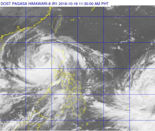
Typhoon ‘Karen’ can be seen swirling on the left of Luzon in this satellite photo from the Pagasa website. A severe tropical storm can be seen on the lower right portion of the image as it nears the Philippine area of responsibility. PAGASA PHOTO
Typhoon “Karen” (international name: Sarika) further weakened on Sunday morning as it was about to exit the Luzon landmass through Pangasinan, the weather bureau said.
In its 11 a.m. bulletin, the Philippine Atmospheric, Geophysical, and Astronomical Services Administration (Pagasa) raised Signal No. 2 over Pangasinan, Tarlac, Zambales and La Union.
Signal No. 1 was hoisted over Ilocos Sur, the Mt. Province, Ifugao, Nueva Vizcaya, Quirino, Benguet, Aurora, Nueva Ecija, Pampanga, Bulacan, Bataan, Metro Manila, Cavite, Rizal, Laguna, Batangas and Nothern Quezon.
Karen packed maximum sustained winds of up to 120 kilometers per hour near the center and gustiness of up to 200 kph, as it moved west northwest at 22 kph.
The typhoon was last plotted near Bolinao, Pangasinan, and was expected to exit the Philippine area of responsibility (PAR) on Monday morning.
Pagasa said a severe tropical storm was expected to enter PAR on Monday afternoon and will be named “Lawin.” CBB/rga