Typhoon ‘Karen’ accelerates further; more areas under Signal No. 3

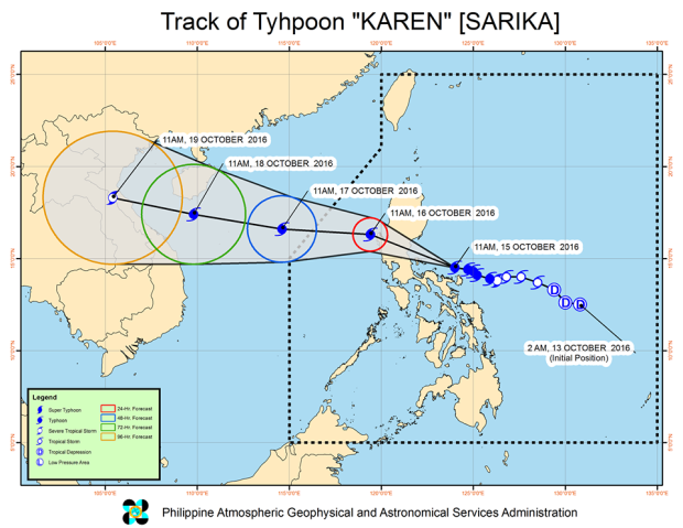
This image from Pagasa’s Facebook page shows the forecast track of Typhoon Karen as of Saturday afternoon.
More areas were place under Tropical Cyclone Warning Signal number Signal No. 3 on Saturday as typhoon “Karen” (international name: Sarika)accelerated and moved toward Quezon and Aurora provinces, the state weather bureau said.
In its 2 p.m. advisory, the Philippine Atmospheric, Geophysical Astronomical Services Administration (Pagasa) said Karen was spotted 120 kilometers (km) north northwest of Virac, Catanduanes.
Pagasa said the typhoon has a maximum sustained winds of up to 130 kilometers per hour (kph) near the center and gustiness of up to 180 kph.
The typhoon is moving faster 20 kph from 17kph as it heads northwest. It is expected to make landfall over the Quezon-Aurora area on Sunday morning.
The weather bureau raised Signal No. 3 in Camarines Norte, northern Quezon including Polillo Island, Nueva Ecija, Nueva Vizcaya, Tarlac, Pangasinan, Aurora and northern Zambales.
Article continues after this advertisementThe provinces of Albay, Catanduanes and Camarines Norte continue to experience heavy rainfall because of the typhoon, prompting the state weather bureau to issue a red rainfall warning.
Article continues after this advertisementSignal No. 2 was raised in the areas of Catanduanes, rest of Quezon, Quirino, Camarines Sur, Rizal, Bulacan, rest of Zambales, La Union, Pampanga, Tarlac, Ifugao, Benguet and Southern Isabela.
Pagasa said storm surges and flash
The areas of Albay, Sorsogon, Masbate, including Ticao and Burias Island, rest of Isabela, Ilocos Sur, Romblon, Marinduque, Oriental Mindoro, Batangas, Laguna, Cavite, Metro Manila, Bataan, Abra, Kalinga znd Mt. Province were placed under signal no. 1.
Pagasa said storm surges were possible in coastal areas of those under Signals No. 2 and 3, while flashfloods and landslides may happen in areas under any warning signal. IDL
RELATED STORIES
5 areas under signal no. 3 as Typhoon ‘Karen’ heads for Luzon