Karen at full impact Sunday, threatens Luzon
MANILA — A potential typhoon is on a direct path to hit Luzon this weekend.
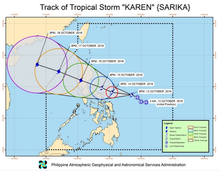
The Philippine Atmospheric Geophysical Astronomical Services Administration (PAGASA) said Tropical Depression Karen, which developed from a low pressure area monitored east of Mindanao, has been moving west northwest towards the Luzon landmass.
It was packing maximum sustained winds of 50 kilometers per hour near the center and gusts of 70 kph, on Thursday, and the cyclone will intensify as it nears the Bicol and Eastern Visayas regions on Friday, October 14.
“By Saturday (October 15), the entire Luzon and Visayas will have rains, especially Bicol, Quezon and Aurora,” PAGASA weather forecaster Benison Estareja said.
The full impact will be felt Sunday as the cyclone is expected to become a full-blown typhoon while it barrels towards northern and central Luzon.
Article continues after this advertisementBased on its speed and track, the potential typhoon is forecast to make landfall over northern Quezon and Aurora on Sunday afternoon October 16.
Article continues after this advertisement“It is intensifying and it’s possible it will become a typhoon before it makes landfall,” Estareja said.
PAGASA is expected to raise cyclone warning signals on Friday.
Estareja said the typhoon would continue to bring stormy weather on Monday, October 17, particularly over the Ilocos provinces, Zambales, Bataan as well as Metro Manila.
The cyclone is forecast to be out of the Philippine area of responsibility by Monday night.
The recent cyclones tracked over the country’s northernmost boundaries.
Typhoon Ferdie (international name Meranti) and Typhoon Helen (Megi) devastated Batanes and surrounding islands last month. SFM/rga
