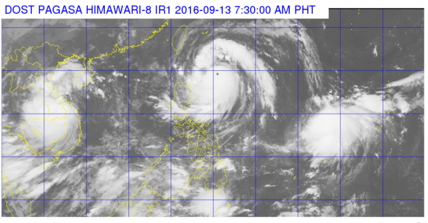
Batanes was placed under Signal No. 3 as Typhoon “Ferdie” (international name: Meranti) intensified and posed a threat over extreme northern Luzon on Tuesday.
The typhoon packed maximum sustained winds of 215 kilometers per hour (kph) near the center, up from 195 kph and gusts of up to 250 kph, up from 230 kph, the Philippine Atmospheric, Geophysical and Astronomical Services Administration (Pagasa) said.
Signal No. 2 was raised in Northern Cagayan and Babuyan Group of Islands, while Signal No. 1 was raised over the rest of Cagayan, northern Isabela, Kalinga, Apayao, Abra and Ilocos Norte.
Ferdie was last tracked 510 kilometers east of Calayan in Cagayan and was moving west northwest at 22 kph.
“Residents in Northern Luzon are advised to take precautionary measures against impacts of very strong winds and heavy rainfall,” Pagasa said.
By Wednesday, Ferdie is forecast over the vicinity of Basco, Batanes and by Thursday morning, it will be 345 kilometers west northwest of Itbayat in Batanes, or outside the Philippine area of responsibility.
Moderate to heavy rains are expected within the 500 kilometer-diameter of the typhoon.
Cloudy skies with light to moderate rains and isolated thunderstorms are expected over Northern Mindanao, Visayas and the rest of Luzon, Pagasa said.
Partly cloudy to cloudy skies with isolated rainshowers or thunderstorms will prevail over the rest of Mindanao.
In its 7:30 a.m. update, Pagasa said a thunderstorm is affected Bataan, Zambales, Cavite and Batangas. Laguna and Quezon may experience the same in the next two hours, while Metro Manila may get light to moderate showers. IDL
RELATED STORIES
Signal No. 1 up in Batanes, Babuyan islands due to ‘Ferdie’
Signal No. 1 up in 8 areas as ‘Ferdie’ intensifies further


