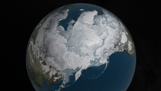
Arctic sea ice reaches new record low mark for wintertime

This image provided by NASA shows Arctic sea ice at it maximum, the lowest on record. The winter maximum level of Arctic sea ice shrank to the smallest on record, thanks to extraordinarily warm temperatures, federal scientists said. The National Snow and Ice Data Center says sea ice spread to a maximum of 5.607 million square miles in 2016. That’s 5,000 square miles less than the old record set in 2015, a difference slightly smaller than the state of Connecticut. AP
WASHINGTON, United States — The growth of Arctic sea ice this winter peaked at the lowest maximum level on record, thanks to extraordinarily warm temperatures, federal scientists said Monday.
The National Snow and Ice Data Center says ice covered a maximum of 5.607 million square miles (14.52 million square kilometers) of the Arctic Ocean in 2016. That’s 5,000 square miles (12,950 square kilometers) less than the old record set in 2015 — a difference slightly smaller than the state of Connecticut.
READ: Arctic air temperature highest since 1900 — report | Global warming reopens Pacific-Atlantic passage in Arctic
It’s also some 431,000 square miles (1.1 million square kilometers) less than the 30-year average. That difference is the size of Texas and California combined.
Records go back to 1979 when satellites started measuring sea ice, which forms when Arctic Ocean water freezes.
This year’s ice didn’t break the record by much, but it’s “an exclamation point” on a longer-term trend, said NASA scientist Walt Meier, who helped calculate the data.
The sub-par showing doesn’t necessarily mean that the minimum extent this summer will also break a record, scientists said. The summer minimum is more important for affecting Earth’s climate and weather.
Data center scientist Julienne Stroeve says winter temperatures over the North Pole were 16 degrees Fahrenheit warmer than normal, while other parts of the Arctic ran 4 to 11 degrees F warmer than normal.
Data center chief Mark Serreze said in a press release, “I have never seen such a warm, crazy winter in the Arctic.”
It was so warm that the Barents Sea was “pretty much close to ice -free for almost the whole winter, which is very unusual,” Meier said.
Stroeve said early indications show that the sea ice is thinner than last year.
A leading but still controversial theory says loss of sea ice in the Arctic may change the jet stream and bring more extreme weather to the United States, Stroeve said.
The new report reveals “just the latest disturbing data point in a disturbing trend wherein climate changes are happening even faster than we had forecast,” Pennsylvania State University climate scientist Michael Mann said.