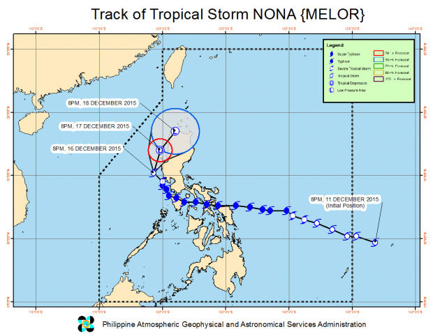
“Nona” (international name: “Melor”) has become a severe tropical storm on Wednesday afternoon and a second cyclone named “Onyok” is expected to make landfall in Mindanao over the weekend. PAGASA PHOTO
While southern Luzon and northern Visayas are still reeling from the havoc caused by Typhoon “Nona,” a second cyclone is expected to make landfall in Mindanao over the weekend.
Nona (international name: Melor) has become a severe tropical storm on Wednesday afternoon but still threatened the coast of western Luzon with winds of up to 130 kilometers per hour (kph) and moderate to heavy rains.
It continued to crawl west northwest at 7 kph as it skirted Cavite, Batangas and Zambales.
But the Philippine Atmospheric Geophysical and Astronomical Services Administration (Pagasa) said Nona would eventually curve southwest and weaken further into a tropical depression on Thursday.
The storm will pass close to Mindoro and Palawan on its way out, diminishing into a low pressure area over the West Philippine Sea when it exits the Philippine area of responsibility on Saturday.
With Nona in the western seaboard, Tropical Depression “Onyok” will rapidly bore down toward Mindanao with maximum winds of 45 kph, barreling west northwest at 20 kph.
Pagasa said Onyok would make landfall over eastern Mindanao early Friday and cut across Mindanao for the next two days before it exits in the West Philippine Sea on Sunday.
Pagasa forecaster Aldczar Aurelio said Onyok was carrying moderate to heavy rains within a 75-km diameter, would not likely intensify into a tropical storm because the prevailing wind shear would break up the gathering cloud formation. Dona Z. Pazzibugan