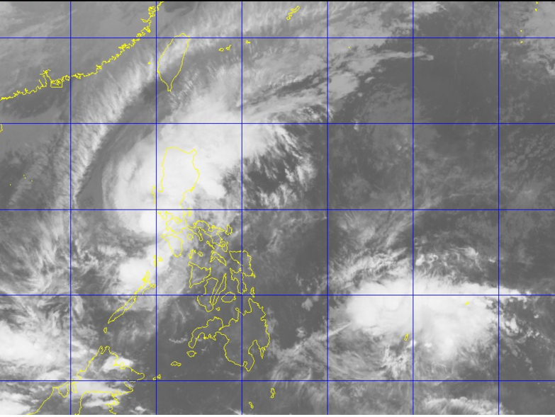
This satellite photo shows clouds of Typhoon ‘Nona’ still covering much of Luzon. At bottom right, is a tropical depression threatening to enter the Philippine area of responsibility (PAR) Wednesday. PAGASA WEBSITE
Typhoon “Nona” (international name Melor) again slightly weakened early Wednesday as it traversed the West Philippine Sea, the state weather bureau said.
On Tuesday night, Nona stranded thousands of passengers in Metro Manila due to its heavy to torrential rain.
This developed as a new storm was forecast to cross the Philippine area of responsibility (PAR) on Wednesday.
Storm signals continued to be hoisted in the following areas:
Signal No. 3
Northern Occidental Mindoro including Lubang Island
Signal No. 2
Bataan, Batangas, Cavite, Northern Oriental Mindoro and the rest of Occidental Mindoro
Signal No. 1
Metro Manila, Pampanga, Southern Zambales, Bulacan, Laguna, Calamian group of Islands and the rest of Oriental Mindoro
Nona packed maximum sustained winds of 130 kilometers per hour near the center and gusts of up to 160 kph, the Philippine Atmospheric, Geophysical and Astronomical Services Administration (Pagasa) said in an advisory.
The typhoon, last tracked at 125 kilometers northwest of Calapan City in Oriental Mindoro, crawled west northwest at 9 kph.
Moderate to heavy rain is seen within the 250-kilometer radius of Nona.
Flashfloods and landslides are still expected in the provinces of Mindoro, Bataan, Zambales, Pampanga, Bulacan and Metro Manila, Pagasa said.
Nona, which made landfall five times on Monday and Tuesday, prompted the suspension of classes and dozens of domestic flights. Pagasa said it would weaken to a low pressure area by the time it left the PAR on Friday.
Meanwhile, a tropical depression monitored by the weather bureau was last observed 1,425 kilometers east southeast of Mindanao.
It will be locally named Onyok once it enters the PAR. CB