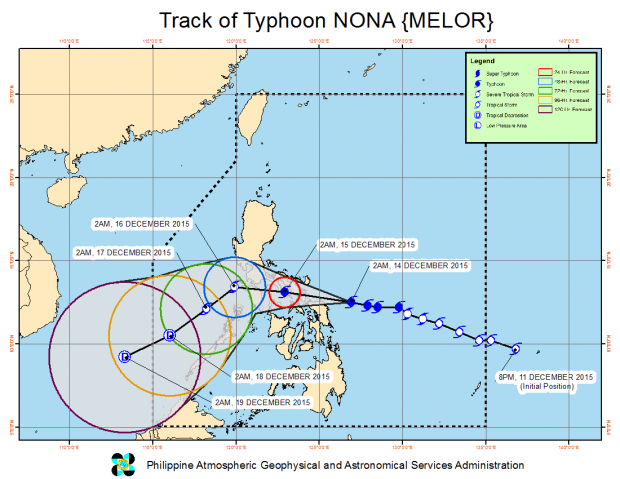
Typhoon “Nona” (international name: “Melor”) made landfall over Batag in Northern Samar midday Monday, the state weather bureau said.
In a televised press briefing, weather forecaster Aldczar Aurelio from the Philippine Atmospheric, Geophysical and Astronomical Services Administration said the typhoon made landfall at around 11 a.m.
Storm signals were placed in the following areas:
Signal No. 3
Catanduanes, Camarines Sur, Albay, Sorsogon, Masbate, Ticao and Burias Islands, N. Samar, E. Samar, Samar and Biliran
Signal No. 2
Camarines Norte, Marinduque, Romblon Or., Mindoro Occ., Mindoro, Batangas, Laguna, Southern Quezon, and Leyte
Signal No. 1
Metro Manila, Bataan, Bulacan, Lubang Islands, Coron, Rest of Quezon, Polillo Islands, Southern Leyte and N. Cebu
The typhoon will make a second landfall over Sorsogon early evening before it crosses Albay and Burias Island, Aurelio said.
Metro Manila may experience the effects of the typhoon starting Monday night.
Nona was last tracked 85 kilometers east of Catarman in Northern Samar with maximum sustained winds of 150 kilometers per hour (kph) and gusts of up to 185 kph.
It continued to move west at 17 kph.
The typhoon will dump heavy to, at times, intense rains within its 300 kilometer radius.
Pagasa warned of flashfloods and landslides over areas under Signals No. 2 and 3 while storm surges of up to four meters are also possible. RAM/JE
RELATED STORIES
Signal 1 up in Metro Manila, 14 areas; ‘Nona’ to landfall over Sorsogon
Strong tropical storm ‘Nona’ threatens PH
