Signal No. 1 up in Visayas, Mindanao as ‘Ramon’ maintains strength—Pagasa
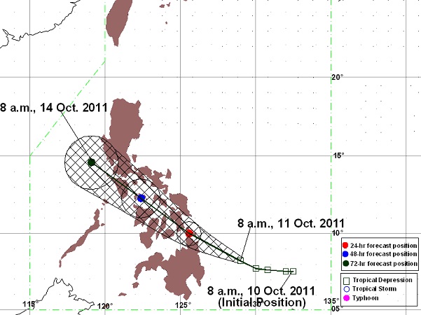
PAGASA Track as of 8 a.m., 11 October 2011
MANILA, Philippines – Tropical depression “Ramon” has maintained its strength as it continued to threaten the Mindanao and Visayas regions, the Philippine Atmospheric, Geophysical and Atmospheric Services Administration (Pagasa) said Tuesday.
In its latest bulletin, Pagasa said that Ramon was seen 245 kilometers east of Hinatuan, Surigao del Sur and was packing maximum sustained winds of 55 kilometers per hour near the center.
Ramon was forecast to move west northwestward at 17 kph, Pagasa said.
Signal No. 1 remains up over Eastern Samar, Western Samar, Leyte Provinces, Bohol, Biliran, Camotes Island, Northern Cebu, Northern Negros, Northern Iloilo, Capiz, Masbate, Surigao Del Norte, Siargao Island, Surigao Del Sur, Agusan Del Norte, Dinagat Island, Camiguin Island and Ticao Island.
Residents in low lying and mountainous areas under Storm Signal No. 1 were alerted against possible flashfloods and landslides, Pagasa said.
Article continues after this advertisement“Estimated rainfall amount is from 5-25 millimeters per hour [moderate to heavy] within the 300 km diameter of the Tropical Depression,” the state-run weather bureau said.
Article continues after this advertisementBy Wednesday morning, Ramon is forecast to be 30 km north of Surigao City and is expected to be 30 km south of Romblon on Thursday morning.
By Friday morning, Ramon is expected to be 120 km southwest of Iba, Zambales. Kate Evangelista