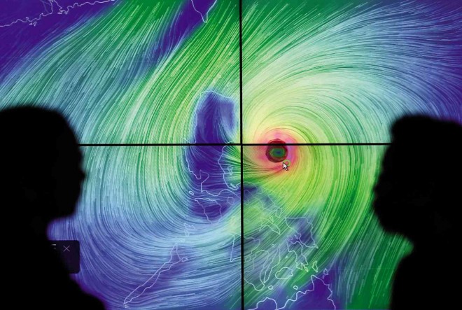
WATCHING TYPHOON ‘LANDO’ Weather forecasters from Pagasa monitor the movement of Typhoon “Lando” (international name: Koppu) projected on the screen as it approaches northern Luzon. Lando is expected to make landfall in Aurora province early this morning and to linger in the country until Tuesday. RAFFY LERMA
Disaster officials on Saturday advised communities in flood-prone areas of northern Luzon to evacuate, warning that Typhoon “Lando” was likely to linger over the country for almost three days, bringing prolonged heavy rain, causing floods and sparking storm surges.
Lando (international name: Koppu) was expected to make landfall in Aurora province early this morning and would not leave the country until Tuesday, the Philippine Atmospheric, Geophysical and Astronomical Services Administration (Pagasa) said.
As of 4 p.m. Saturday, Lando was 230 kilometers east of Baler, Aurora, and was moving west at 10 kilometers per hour.
Pagasa Director Esperanza Cayanan said Lando, which has sustained winds of 175 kph and gusts of 210 kph, could strengthen as it got closer to the country.
Cayanan said another typhoon farther east and a high-pressure area north of the Philippines would hold Lando in a “semistationary” position over northern Luzon.
“It may be semistationary once it hits,” she said.
Although Lando will not directly hit Metropolitan Manila, Cayanan said the typhoon had a diameter of 600 km, so huge that even southern regions were likely to be affected by strong winds and rain.
Areas hit by the typhoon will suffer “heavy to intense rainfall” with possible tsunami-like storm surges in coastal areas, she said.
Public storm signals
Pagasa placed Aurora under public Storm Signal No. 4, which means winds of 171-220 kph that pose “very heavy damage” to high-risk structures and “heavy damage” to medium-risk structures.
Public Storm Signal No. 3, with winds of 121-170 kph, was raised over the provinces of Isabela, Quirino, Nueva Vizcaya, Nueva Ecija and Ifugao and in northern Luzon, including Polillo Islands.
Pagasa raised public Storm Signal No. 2, with winds of 61-120 kph, over Cagayan, including Calayan and Babuyan Group of Islands, Benguet, Mountain Province, Abra, Kalinga, Apayao, Ilocos Norte, Ilocos Sur, La Union, Pangasinan, Zambales, Tarlac, Pampanga, Bulacan Rizal, the rest of Quezon, Camarines Norte and Metro Manila.
Vicente Malano, acting Pagasa administrator, said Metro Manila would not come under a higher storm warning signal.
Storm signal No. 1 went up over Batanes, Bataan, Cavite, Laguna, Batangas, Lubang Island, northern Oriental Mindoro, Marinduque, Camarines Sur, Albay and Catanduanes.
Aldczar Aurelio, a forecaster with Pagasa, said Lando was expected to be in the vicinity of Casiguran, Aurora, today; at Hingyon, Ifugao, tomorrow; and Nueva Era, Ilocos Norte, on Tuesday.
On Wednesday, Lando will be 40 km northwest of Calayan, Cagayan, and on Thursday, it will be 60 km north of Itbayat, Batanes, Aurelio said.
Aurelio said the tail-end of a cold front, high pressure in the West Philippine Sea, and nearby Typhoon “Champi,” moving, reduced the speed of Lando.
Civil defense officials warned that waves as high as 14 meters could occur at sea and banned all vessels from sailing in more than half of the country.
The ban on sailings left more than 4,000 travelers stranded in ports in Luzon and the Visayas yesterday.
The Philippine Coast Guard reported that 4,973 travelers were stranded in ports in Southern Tagalog, Bicol, Aparri and Cebu.
Officials also warned of possible floods in river basins and urged residents to heed orders to evacuate ahead of any incident.
“If you are told you need to evacuate, then we appeal to you to evacuate,” said Alexander Pama, chief of the National Disaster Risk Reduction and Management Council (NDRRMC).
Pama also urged the public to cancel any travel plans over the weekend.
“We would like to stress that Lando is not like the usual typhoons [that take only] a day to cross [the Philippines]. Based on forecasts, this will possibly last until Tuesday,” he said.
Interior Secretary Mel Senen Sarmiento reminded local officials in northern Luzon to ensure that all disaster preparedness measures would be implemented.
“We have been communicating with them since several days ago to reiterate the importance of disaster preparedness at this time,” Sarmiento said.
Officials said residents in Lando’s path were already evacuating coastal and riverside areas, although they did not give exact figures.
AccuWeather, a weather information provider, said Lando could drench large areas of rice-growing Luzon with between 300 and 600 millimeters of rain and cause life-threatening flooding and mudslides.
P-Noy warning
President Aquino went on television on Friday and warned that Lando could be uniquely destructive because it would bring intense rain over a long period of time.
It was the first time Mr. Aquino personally issued a storm warning on television since Supertyphoon “Yolanda” (international name: Haiyan) barreled through central Philippines in November 2013, leaving more than 7,300 people dead and missing.
Mr. Aquino said the government estimated that 1.5 million families, or about 7.5 million people, would need relief assistance.
In a statement, Social Welfare Secretary Corazon Soliman said the Department of Social Welfare and Development had prepared food aid for 44,450 families in 87 municipalities in 10 provinces in the Cordillera Autonomous Region, Cagayan and Calabarzon (Cavite, Laguna, Batangas, Rizal and Quezon).
Soliman said the National Resource Operations Center had evacuated 72 families from Isabela to five shelters run by the provincial government. With reports from Niña P. Calleja, Gil C. Cabacungan, Marlon Ramos, Jaymee T. Gamil, AP and AFP
RELATED STORIES
Lando further intensifies; Signal No. 4 up in Aurora, Southern Isabela
Expect heavy to intense rains in Luzon–Pagasa

