NORTHERN Luzon is again in the path of a storm for the second time this month.
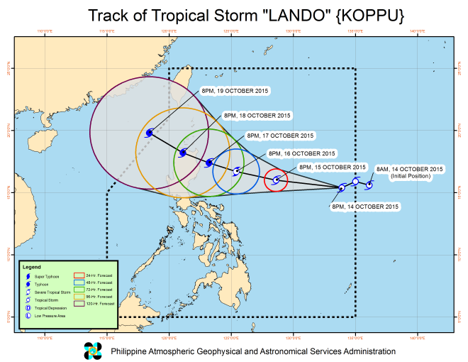
Tropical Storm “Lando” (international name: Koppu) is on track to hit northern Luzon later this week, based on the weather bureau’s forecast issued Wednesday night.
If it maintains its current track and speed, the storm is expected to make landfall in the vicinity of Gattaran, Cagayan on Monday.
Lando intensified into a storm before reaching the country’s eastern seaboard Wednesday afternoon.
Packing maximum winds of 65 kilometers per hour and gusts up to 80 kph, the cyclone sped westwards towards the Luzon landmass at 22 kph.
It is forecast to veer northwestwards as it nears land such that the center of the cyclone is expected to be over Cagayan province by Monday.
The Philippine Atmospheric, Geophysical and Astronomical Services Administration (Pagasa) said the storm carried moderate to heavy rains within its 500-km diameter.
Fishermen were warned not to venture out along the seaboards of northern Luzon and the eastern seaboard of Central Luzon.
Aside from the gale warning, Pagasa has so far not raised storm warning signals.
Northern Luzon has been experiencing light to moderate rains since the start of the week due to the northeast monsoon.
Lando is the 12th cyclone to hit the country this year, when many parts of the country are experiencing prolonged drought due to what has become one of the strongest El Niño episodes on record.
The last cyclone, Tropical Storm “Kabayan” dumped heavy rains over northern Luzon from Sept. 30 to Oct. 2, making landfall over Aurora province before it headed out.
The last storm left at least two people dead, stranded dozens of fishermen at sea for days and reportedly left at least P841 million in agricultural damage but also replenished major reservoirs in Luzon which have fallen to critical levels after months of El Niño.
