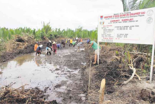
Riverside villages await life-changing projects

ROADWORK Residents of Barangay Pagao in Bombon, Camarines Sur province, work in a road-opening project under the Department of Social Welfare and Development program. Each of them receives P270 daily for their labor. JUAN ESCANDOR JR.
IGNACIO Villacote never thought that after three decades, he will one day be able to sleep soundly on a rainy night at his home in his village along the Bicol River in Magarao, Camarines Sur province.
A councilor of Barangay Carigsa, Villacote, 52, lost his old home in 1982 to the raging waters of the swollen Bicol River—the community’s only connection to the town center. And over the years, 14 other houses and a basketball court have been swallowed by the current.
By the end of this year, Carigsa residents hope that the constant threat of flooding will end when a 300-meter levee, costing some P27 million, is completed to stop the river from eating up more lands.
So far, the village has lost about 25 meters of land from the river to its banks. Villacote points to water hyacinths floating dozens of meters from the torn rip-rap where his house once stood.
Saltwater intrusion
Article continues after this advertisementCarigsa is located 3 kilometers from the mouth of the river, which drains to the San Miguel Bay on the northeastern seaboard of the province facing the Pacific Ocean. Saltwater intrusion from the bay has laid to waste more than 100 hectares of rice fields in the village, Villacote says.
Article continues after this advertisementNow, only 50 families remain in the community, subsisting on fishing and making nipa shingles from the abundance of nipa groves. They are left out by development and long-forgotten by politicians.
Fishing brings just enough food on the family table, or about P300 per fishing trip, says Albert Cananaman, 31. The river supplies a bounty of shrimps and crabs, but only during the months of April and May, when Cananaman would earn as much as P1,000 per trip.
Lady Anne Aleta, 18, a high school graduate with no means to go to college, earns about P200 for 50 nipa shingles she makes throughout the day.
So near yet so far
Carigsa is so near yet so far from the town center, its main source of basic necessities and services. Without any road directly connecting it to the poblacion, villagers pass through a 15-km loop going north to Calabanga town, then another 10 km going south to Naga City.
The fare going back and forth is P150, Villacote says. But across the idle rice fields on the upper portion of the village further north off the Bicol River, the distance is only 1.7 km.
Located at the edge of the Bicol River Basin, the drainage area of the Bicol Peninsula, Magarao—along with other areas in the third district—is prone to flooding and storm surge. The district (population: 473,235, as of 2010) comprises Naga and the towns of Calabanga, Bombon, Magarao, Canaman, Pili, Ocampo and Camaligan.
The mighty Bicol River crisscrosses six of the eight towns going to the San Miguel Bay, where it empties. It is thus with great anticipation that the villagers wait for the completion of the infrastructure projects intended to ease the effects of extreme weather in the flood-prone areas.
The projects are undertaken by the Department of Public Works and Highways, and facilitated by Rep. Leni Robredo.
Hopefully, Villacote says the levee will also stop the intrusion of seawater in the rice fields. A road project linking the village to the town center is also in the works, he adds.
Further north to Barangay Balongay in Calabanga, the Bicol River stretches to about 600 meters across toward the town of Cabusao. Jose Asuro Jr., 34, the village chief of Balongay, says its own P31-million levee project is set for completion by year end to provide immediate protection to some 100 houses near the banks.
Asuro recalls that 60 percent of the houses in his village were destroyed by flood when the river swelled last year during the height of Typhoon “Glenda” (international name: Rammasun), the first typhoon to hit Bicol after an eight-year lull.
But the proposed levee, which is 300 meters long and four meters in height, is not enough assurance that Balongay will no longer be flooded. Another river runs downstream at the village boundary where the construction of the facility stops.
Once completed, the levee can only slow down floodwaters and give people enough time to evacuate. In past typhoons, flood coming from all directions would suddenly engulf more than half of the village.
Balongay has a population of 1,418 distributed in 302 households. Its residents rely on fishing and making nipa shingles for their livelihood, Asuro says.
The abundance of wild nipa groves is a lifeline to residents as there is no virtual single investment in agriculture.
Seawall protection
When Glenda struck on July 16, villages facing the San Miguel Bay bore the brunt of storm surges that swept away houses and destroyed farms.
Alvin P. David, village chief of Belen in Calabanga, narrates that the storm surge dumped tons of bugitis (tiny cone shells) on 114 ha of rice fields on their village and the adjoining Barangay Paolbo.
David says a 1-km seawall now being constructed in his village will allow dozens of farmers to rebuild their paddies.
In the adjoining coastal village of Bonot-Sta. Rosa, also in Calabanga, another seawall stretching almost 1 km is being built.
The village has a population of 4,132 and a land area of 369 ha. Its chief, Elmer Tanael, 47, says 615 of the 817 households staying near the coast will benefit from the 4-meter-high, 3-meter-wide seawall.