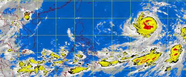
MT Satellite image August 4, 2015, 7:01 a.m. Screengrab from https://www.pagasa.dost.gov.ph/
“Soudelor,” the weather disturbance forecast to enter the Philippine area of responsibility on Wednesday, has intensified into a supertyphoon, the state weather bureau said.
The supertyphoon is packing maximum sustained winds of 210 kilometers per hour near the center and gusts of up to 245 kph, the Philippine Atmospheric, Geophysical and Astronomical Services Administration (Pagasa) said.
Soudelor is not expected to make a direct effect to the country nor make landfall but it will enhance the southwest monsoon or habagat.
READ: Pagasa sees stronger habagat as typhoon nears
Signal No. 1, however, may be raised in extreme Northern Luzon as the supertyphoon head towards Taiwan.
Soudelor, which will be called “Hanna” when it enters PAR, was last located 1,995 kilometers east of Luzon and it moved 20 kph west northwest.
READ: Bagyong Hanna, papasok sa PAR sa Miyerkules
Meanwhile, an intertropical convergence zone continues to affect Palawan and Mindanao.
Cloudy skies with light to moderate rains and isolated thunderstorms will be experienced over Mindanao, Western and Central Visayas and Palawan.
Partly cloudy to cloudy skies with isolated thunderstorms will prevail over Metro Manila and the rest of the country.
Light to moderate winds blowing from the east to southeast will prevail over Northern and Central Luzon and coming from the southwest to south over the rest of the country.
The coastal waters throughout the archipelago will be slight to moderate. IDL