‘Chan-hom’ intensifies into typhoon as it nears PAR
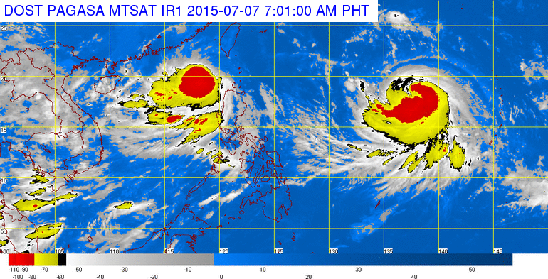
This satellite image from Pagasa shows the location of Tropical Storm “Egay” (Linfa) and Typhoon “Chan-hon” (international name).
The weather disturbance seen to enter the Philippine area of responsibility (PAR) has intensified into a typhoon, the state weather bureau said Tuesday morning.
“Chan-hom,” which will be locally named Falcon when it enters PAR on Tuesday evening or early Wednesday, packed maximum sustained winds of 120 kilometers per hour near the center and gusts of up to 150 kph, the Philippine Atmospheric, Geophysical Services Administration said in a weather advisory.
The typhoon moved at a speed of 20 kph west northwest.
Samuel Duran of Pagasa said Chan-hom may intensify into a supertyphoon as it may still gain strength at sea.
A supertyphoon has maximum sustained winds of at least 220 kph.
Chan-hom was last located 1,715 kilometers east of Luzon.
The Philippines is still reeling from the onslaught of Tropical Storm “Egay” (international name: Linfa), which is expected to exit PAR Tuesday morning.
READ: ‘Egay’ to exit PH Tuesday morning–Pagasa
Duran said Chan-hom will not make landfall in the Philippines and will pass over the boundary of PAR and may exit by Thursday.
However, when it enters PAR, Chan-hom won’t make a direct impact to the country but would enhance “habagat” or the southwest monsoon which will bring rains in parts of the country including Metro Manila.
There is also a possibility that the typhoon will interact with Egay but they must have a distance of 1,400 kilometers from each other.
Duran explained that the interaction is called the Fujiwhara effect. Chan-hom, which is the stronger cyclone, will dictate the pace of Egay but the cyclones will not merge. IDL