‘Quiel’ weakens, to leave Sunday noon
MANILA, Philippines – “Quiel” (international name: Nalgae) has weakened as it moves west over the West Philippine Sea, according to the latest weather bulletin of the Philippine Atmospheric, Geophysical and Astronomical Services Administration (Pagasa).

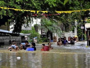
Residents wade through the floodwaters as they evacuate to safer grounds following massive flooding in Calumpit, Bulacan and worsened by typhoon Quiel that brings heavy rains and flash flood in the area. ARNOLD ALMACEN/INQUIRER
As of 11 a.m. Sunday, Quiel was spotted 290 kilometers west of Baguio city with maximum winds of 130 kilometers per hour near the center and gustiness of up to 160 kilometers per hour, Pagasa said.
The diameter of Quiel stayed at 500 kilometers and was estimated to bring 15-25 millimeters of rainfall.
Public Storm Warning Signal no. 1 remained over Ilocos Sur, La Union, Zambales and Pangasinan.
Meanwhile, all signals in other regions have been lowered.
The southwest monsoon was expected to cause scattered to widespread rains over the western section of Southern Luzon.
Article continues after this advertisementQuiel was expected to exit the Philippine Area of Responsibility (PAR) by Sunday afternoon and headed west toward Vietnam. It might also gain more strength since it was over the West Philippine Sea.
Article continues after this advertisementBy Sunday evening, Quiel is expected to be 500 kilometers west of Baguio City, Pagasa said.
Pagasa was monitoring another low pressure area (LPA) over the Pacific ocean, 660 kilometers east of Visayas.
The LPA spotted east of Mindanao over the Pacific Ocean was estimated to move west or northwest, possibly hitting the eastern part of Visayas or Luzon.
Pagasa was closely monitoring the LPA if it would develop into a tropical depression since it was already within PAR. But the LPA, the weather bureau said, has no direct effect to the country since it was still too far.
Originally posted at 6:17 am | Sunday, Oct. 2, 2011