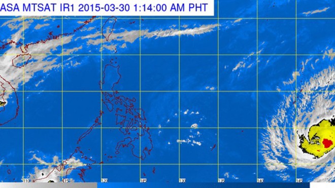
A typhoon headed towards Luzon is expected to enter the Philippine area of responsibility (PAR) on Wednesday, the weather bureau said.
The effects of the typhoon with the international name Maysak will start to be felt on land by Friday, the Philippine Atmospheric Geophysical Astronomical Services Administration (Pagasa) said.
Meteorologists said that unless it changes track, the typhoon will affect the eastern side of Luzon, spanning northern and Central Luzon and the Bicol region.
The third cyclone to hit the country this year, the typhoon will be named “Chedeng” once it enters the PAR.
As of Sunday, the typhoon registered sustained winds of up to 130 kilometers per hour and gusts up to 160 kph.
It was over the Pacific Ocean about 2,800 km east of Mindanao, moving westward at 20 kph.
“There is no scenario yet that it will further intensify, although there’s a possibility since it is still over the ocean where it may gather strength,” Pagasa meteorologist Buddy Javier said.
He said the typhoon was on track towards northern Luzon.
The latest cyclone comes just two weeks after Tropical Storm “Betty” (international name: Bavi) entered the Philippine area of responsibility on March 17.
Due to the prevailing northeast monsoon, Betty rapidly weakened into a low pressure area which brought light to moderate rains over Luzon before dissipating after a few days.
Javier said it was not unusual to have a typhoon in April, the height of the dry season, since Pagasa records showed the country on the average got at least one typhoon during the month.
He said the northeast monsoon, which brings cooler weather, had not completely ceased although it was getting weaker.
