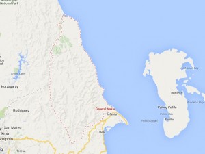
“We have to transfer them to the evacuation centers for their own safety. I’m glad that most of them evacuated voluntarily,” General Nakar Mayor Leovigildo Rozul said over the phone.
Rozul said local residents, particularly those living in five villages along the riverbanks who lost loved ones in the 2004 tragedy, have been experiencing recurring trauma every time there is a typhoon and strong rains.
Rozul said moderate rains started to pour Sunday evening but it got stronger by Monday morning.
He said the local government established a monitoring station atop the Sierra Madre to keep a close watch on the flow of Agos River, especially during typhoons.
Rozul said he also advised the Agta tribesmen living in Sierra Madre mountain villages to also observe safety precaution and to readily evacuate if the heavy rainfall continuous.
“Landslide is not a remote incident during continuous heavy rains,” he said.
In Infanta, the town’s Disaster Risk Reduction and Management Council (DRRMC) is closely watching the Agos River.
“We’ve been monitoring the river flow every 10 minutes through the automated water level sensor,” said Ron Crisostomo, DRRMC coordinator.
Infanta Vice Mayor Grace America said riverbank residents have transferred to their respective barangay halls as safety measures.
On Nov. 29, 2004 at the height of continuous rains brought by three successive typhoons, the Agos River between Infanta and General Nakar towns overflowed and killed over a thousand people.
The towns were inundated with mud and water that carried huge logs and other forest debris, which cascaded from the Sierra Madre where the river originates.
Massive logging in the Sierra Madre mountain ranges has been blamed for the tragedy that also destroyed billions of pesos-worth of properties.
Meanwhile, Janet Geneblazo-Buelo, Quezon public information officer, said 44,600 residents, mostly from coastal areas, have been evacuated since Saturday.
The evacuees were scattered in 315 evacuation centers.
As of Monday morning, northern Quezon has been placed under storm Signal Number 2 while its southern part, the Lamon Bay and Bondoc Peninsula areas, is under Signal Number 3.