Storm surge simulation as of Saturday, 8 a.m. PST Units are in centimeters (cm).
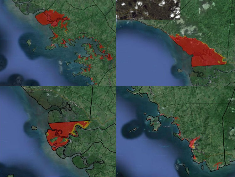
Storm surge simulation for the towns of (clockwise from upper left) Tarangnan, Sta. Margarita, Catbalogan and Gandara. Image from Project NOAH.
MANILA, Philippines–The Department of Science and Technology (DOST) on Saturday said that storm surges caused by Typhoon Ruby (international codename: Habagat) may reach up to 4.6 meters or 15 feet.
DOST’s Project Nationwide Operational Assessment of Hazards (Project NOAH) said in its 2 p.m. advisory that the towns of Tarangnan, Sta. Margarita, Gandara and Catbalogan in Western Samar may experience storm surges as high as 3.6 meters (11.8 feet) to 4.6 meters (15 feet).
On the other hand, simulations for the municipalities of Mobo and Dimasalang in Masbate show storm surges at around 3.4 meters (11.15 feet) to 4.4 meters (14.4 feet) high.
Below is the list of towns that may be affected by storm surges, according to Project NOAH:
| MUNICIPALITY | SURGE HEIGHT (meters) |
| Tarangnan, Samar | 3.6 – 4.6 |
| Sta. Margarita, Samar | 3.6 – 4.6 |
| Gandara, Samar | 3.6 – 4.6 |
| Catbalogan, Samar | 3.6 – 4.6 |
| Uson, Masbate | 3.4 – 4.4 |
| Mobo, Masbate | 3.4 – 4.4 |
| Dimasalang, Masbate | 2.9 – 3.9 |
| Batuan, Masbate | 2.9 – 3.9 |
| Placer, Masbate | 2.6 – 3.6 |
| Daram, Samar | 2.6 – 3.6 |
| Cawayan, Masbate | 2.6 – 3.6 |
| Palanas, Masbate | 2.5 – 3.5 |
| Esperanza, Masbate | 2.4 – 3.4 |
| Zumarraga, Samar | 2.3 – 3.3 |
| Jiabong, Samar | 2.3 – 3.3 |
| San Remigio, Cebu | 2.1 – 3.1 |
| Ormoc, Leyte | 2.1 – 3.1 |
| Merida, Leyte | 2.1 – 3.1 |
| Medellin, Cebu | 2.1 – 3.1 |
| San Sebastian, Samar | 2.0 – 3.0 |
| Pinabacdao, Samar | 2.0 – 3.0 |
| Motiong, Samar | 2.0 – 3.0 |
| Masbate, Masbate | 2.0 – 3.0 |
| Calbiga, Samar | 2.0 – 3.0 |
| Albuera, Leyte | 2.0 – 3.0 |
| Talalora, Samar | 1.9 – 2.9 |
| Sta. Rita, Samar | 1.9 – 2.9 |
| Paranas, Samar | 1.9 – 2.9 |
| Baybay, Leyte | 1.9 – 2.9 |
| Babatngon, Leyte | 1.9 – 2.9 |
| Cataingan, Masbate | 1.8 – 2.8 |
| Villareal, Samar | 1.7 – 2.7 |
| Tigaon, Camarines Sur | 1.7 – 2.7 |
| Taft, Eastern Samar | 1.7 – 2.7 |
| Tabuelan, Cebu | 1.7 – 2.7 |
| Sta. Fe, Cebu | 1.7 – 2.7 |
| San Jose, Camarines Sur | 1.7 – 2.7 |
| San Fernando, Romblon | 1.7 – 2.7 |
| Sagnay, Camarines Sur | 1.7 – 2.7 |
| Pilar, Cebu | 1.7 – 2.7 |
| Can-Avid, Eastern Samar | 1.7 – 2.7 |
| Cajidiocan, Romblon | 1.7 – 2.7 |
| Bantayan, Cebu | 1.7 – 2.7 |
| Santo Domingo, Albay | 1.6 – 2.6 |
| Manito, Albay | 1.6 – 2.6 |
| Kawayan, Biliran | 1.6 – 2.6 |
| Balud, Masbate | 1.6 – 2.6 |
| Bacacay, Albay | 1.6 – 2.6 |
| Almeria, Biliran | 1.6 – 2.6 |
| San Narciso, Quezon | 1.5 – 2.5 |
| Naval, Biliran | 1.5 – 2.5 |
| Milagros, Masbate | 1.5 – 2.5 |
| Maripipi, Biliran | 1.5 – 2.5 |
| Isabel, Leyte | 1.5 – 2.5 |
| Gumaca, Quezon | 1.5 – 2.5 |
| Calubian, Leyte | 1.5 – 2.5 |
The term “storm surge” became well-known in the Philippines when Super Typhoon Yolanda (Haiyan) caused sea water to inundate and wipe out coastal towns in the Visayas in November last year.
Yolanda survivors recall seeing the water from the shore recede, similar to that of a tsunami, before it rose and destroyed both trees and concrete houses.
Thousands of people in Leyte and Eastern Samar died because of the storm surges.
Simply put, a storm surge is a giant wall of seawater.
The US National Weather Service describes it as an “abnormal rise of water generated by a storm, over and above the predicted astronomical tide.”
The rise in water is caused by a typhoon’s strong winds. The wind circulation creates a vertical column of water below the ocean surface. Once the typhoon reaches shallow water, however, the column of water is forced to go up and inland, flooding beaches and coastal towns.