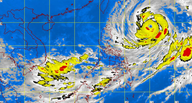
MT Satellite image October 9, 2014, 6:01 a.m. Screengrab from https://www.pagasa.dost.gov.ph/
MANILA, Philippines—Typhoon “Ompong” (international name: Vongfong) was spotted 940 kilometers east southeast of Calayan, Cagayan, as of 4 a.m. Thursday, packing maximum sustained winds of 215 kilometers per hour and gusts of up to250 kph, the state weather bureau said.
Moving slowly at 9 kph, Ompong was tracking a west northwest path, the Philippine Atmospheric, Geophysical and Astronomical Services Administration (Pagasa) said.
Pagasa said Metro Manila, Mimaropa, Calabarzon, Bicol, Visayas and Mindanao will have cloudy skies with light to moderate rainshowers and thunderstorms, while the rest of the country will be partly cloudy to cloudy with isolated rainshowers or thunderstorms.
The coastal waters over the entire archipelago will be moderate to rough, it added.
In its weather forecast, the Philippine Atmospheric, Geophysical and Astronomical Services Administration said the intertropical convergence zone lingers over Mindanao that would bring rains over large parts of the country.
Metro Manila, Mimaropa, Calabarzon, Bicol, Visayas and Mindanao will experience cloudy skies with light to moderate rainshowers and thunderstorms.
Also, Typhoon “Ompong” (international name: Vongfong) was spotted 940 kilometers east southeast of Calayan, Cagayan, as of 4 a.m., packing maximum sustained winds of 215 kilometers per hour and gusts of up to250 kph.
“Ompong” moves slowly at 9 kph tracking a west northwest path.