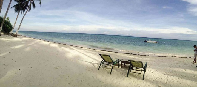
THE MUNICIPALITY of Anda in Bohol province boasts a white-sand beach, which can give Boracay Island in Aklan province a run for its money. PHOTOS BY CARMEL LOISE MATUS
ANDA, Bohol—Bohol province was brought to its knees on Oct. 15, 2013, by a 7.2-magnitude earthquake that killed at least 200 people and destroyed several structures, hurting its tourism industry.
But in less than a year, the province was able to bounce back.
Its tourism industry has even added several attractions from the usual Chocolate Hills, Loboc River Cruise and the beaches on Panglao Island.
Now, the provincial government has included in its tour packages the ruins of the old churches that were destroyed by the tremor as well as the fault line in Inabanga town that released the powerful earthquake.
Bohol Gov. Edgar Chatto admitted that the province’s tourism industry suffered a setback after the earthquake.
But in less than a year, the province has recovered, he added.
“It is moving up fast. There are now raw assets ready to be developed,” he said.
Among these are the province’s unique geological sites that emerged after the earthquake.
These include Maribojoc-Loon Uplifted Reef Flats, Catigbian Karst Window, Sagbayan Spalling Hills and Sinkholes, Danao Gorge and Dagohoy Hill, and Inabanga Ground Rupture.
TOURISTS are not just back but are enjoying the creativity of the people of Bohol province expressed in many ways, like this 380-meter boardwalk in Anda town that brings visitors deep into a mangrove forest.
Eddie Llamedo, information officer of the Department of Environment and Natural Resources in Central Visayas, said the Mines and Geosciences Bureau has recommended that these sites be tapped as geoscience parks in Bohol.
The Maribojoc-Loon Uplifted Reef Flats is a long stretch of land that used to be underwater. Its emergence made the shoreline of Maribojoc and Loon towns wider.
The Catigbian Karst Window is a sinkhole that is rectangular in shape.
Located at the new fault line, Inabanga Ground Rupture is the 5-kilometer crack on the ground that was produced by the 7.2-magnitude earthquake.
The energy released was so intense that one side of the crack was pushed up, creating a 3-meter wall.
As a result, the new fault line has been given the name “Great Wall of Bohol” in apparent reference to the Great Wall of China, but in a much lesser scale.
Since the earthquake, a hill in Barangay Ubojan, Sagbayan town, has been surrounded by sinkholes. This site is called Sagbayan Spalling Hills and Sinkholes.
Another geological site is Danao Gorge and Dagohoy Hill—a narrow valley formed between Dagohoy Hill and a stream that runs through Danao town.
The provincial government also wants to develop tourist spots in the town of Anda, 99 km from the capital city of Tagbilaran.
Anda is a fifth-class municipality with an annual income of not less than P15 million and not more than P25 million, but the town is rich in natural attractions.
The municipality boasts a 2-km white-sand beach and crystal clear water, which tourism officials said are as pretty as the world-renowned Boracay Island in Aklan province.
Under Anda’s jurisdiction is an island where tourists can go spelunking, swimming, exploring mangrove forests or just communing with nature.
Anda Mayor Metodio Amper said the stretch of white-sand beach in Barangay Poblacion is called Quinale, which means land that moves forward like sand dunes.
According to www.bohol.ph, Anda used to be a village of Guindulman town. Quinale was the old name of Anda because of the formations of sand, gravel and corals that piled up because of the waves.
Amper said the sand on Quinale Beach is comparable with the fine sand that made Boracay Island famous.
“I’ve been to Boracay. Our beach is comparable with Boracay,” he said.
Six kilometers from the poblacion is Barangay Badiang, the home of Lamanoc Island. The island boasts caves—some of which were used as burial sites like Shaman’s Cave and Ka Iska’s Cave.
Jars and wooden boat coffins can still be found inside these caves. Some jars, however, were broken by treasure hunters who believed there were valuables inside. They must be disappointed when they found only skeletal remains.
There is also a cave in Lamanoc where prehistoric graffiti can be found on the walls. The inhabitants used their fingers to paint the walls with hematite, the mineral form of iron oxide.
Fortunato Simbajon, 57, a local tour guide, said that before the Spaniards arrived, the island was considered a holy spot where priests and medicine men made offerings to nature spirits, or diwata, who had been believed to reside there.
Indeed, the island is rich with lush vegetation that includes a 2-km stretch of mangrove trees.
The municipality has built a 380-m-long bamboo boardwalk that cuts through the mangrove forests.
At the end of the boardwalk is a docking pier made of nipa and bamboo where small paddle boats manned by the locals are docked.
Tourists can use the small paddle boats to go around the island for 10 minutes.
Cesar Cruz, Philippine Tour Operators Association president, said Anda had the potential to lure tourists.
What the town needs is advertisement, he added.
Cruz said the white sand in Anda is finer than Boracay’s. Lamanoc Island can be added to Bohol’s package tours, he said.
Cruz admitted that Bohol has a lot of attractions that can easily be sold to tourists.
“There are a lot of things to sell in Bohol,” he said in a recent news conference.
“How do we sell Bohol now? Not for charity. Not to come as a volunteer, but we encourage people to come to Bohol and appreciate what it has,” Cruz added.
And not even a 7.2-magnitude earthquake can destroy the beauty of Bohol.