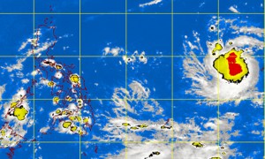
MANILA, Philippines — A tropical depression spotted outside the country was expected to enter the Philippine Area of Responsibility on Sunday evening or Monday morning, the state weather bureau said Saturday.
The Philippine Atmospheric Geophysical and Astronomical Services Administration (Pagasa) said that as of Saturday morning, the tropical storm was spotted at 2, 110 kilometers east of Southern Luzon.
It said the typhoon would be locally named “Glenda” once it enters the country.
Forecaster Glaiza Escullar said that as of noon Saturday, the tropical depression was moving west-northwest at 20 kilometers per hour.
“Based on our estimates, the tropical depression may enter the Philippine area or responsibility on Sunday night or early Monday morning,” Escullar told the Inquirer, adding there was a high probability that it would develop into a storm as it moved closer to the country.
Escullar said that if the weather disturbance continued on its current track, it could make landfall in Northern Luzon on Wednesday.
According to Pagasa’s forecast for Saturday, Palawan and Mindanao would have cloudy skies with light to moderate rains and thunderstorms while Metro Manila and the rest of the country would be partly cloudy to cloudy with isolated rain showers or thunderstorms, it added.
While the tropical depression is still far from the country, Pagasa advised the public to be alert and to monitor for updates.
RELATED STORY
Weather disturbance now a tropical depression—Pagasa
