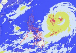
MANILA, Philippines—A storm hovering over the Pacific Ocean is expected to enter the Philippine area of responsibility (PAR) early Sunday morning, but it will not make landfall as it heads for Japan, the weather bureau said on Saturday.
At noon on Saturday, Typhoon “Neoguri” was spotted 1,320 kilometers east northeast of Virac, Catanduanes, the Philippine Atmospheric, Geophysical and Astronomical Services Administration (Pagasa) said in an advisory.
The hurricane, which will be named “Florita” when it enters the PAR, is packing peak winds of 130 kilometers per hour and gustiness of up to 160 kph, Pagasa said.
“It is forecast to move west northwest at 25 kph. It is expected to enter the PAR by early tomorrow morning,” it added.
Forecaster Lenny Ruiz said Neoguri would not make landfall anywhere in the country and its impact would likely be limited to intensifying the southwest monsoon currently prevailing over the archipelago.
A stronger southwest monsoon would mean more rain and general cloudiness in most parts of the country, especially the western sections, including Metro Manila, Ruiz said.
“Based on all models, its track is really to go towards the southern islands of Japan, so we don’t expect it to hit us directly. But it will have the indirect effect of intensifying the southwest monsoon,” he added. DJ Yap
RELATED STORY
