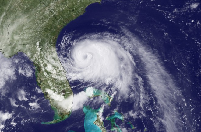
Hurricane Arthur forms in the Atlantic

This Wednesday, July 2, 2014, satellite image taken at 3:35 p.m. EDT and released by the National Oceanic and Atmospheric Administration (NOAA), shows Tropical Storm Arthur moving north off the east coast of Florida. AP
RODANTHE, N.C. — Arthur strengthened to a hurricane early Thursday and threatened to give North Carolina a glancing blow on Independence Day, prompting the governor to warn vacationers along the coast not to risk their safety by trying to salvage their picnics and barbecues.
Forecasters expect Arthur to whip past the state’s Outer Banks on Friday without making landfall. One local remarked that he was more worried about his tomato plants than storm damage.
But North Carolina Gov. Pat McCrory warned: “Don’t put your stupid hat on.”
The first named storm of the Atlantic hurricane season prompted a hurricane warning for much of the North Carolina coast and a mandatory evacuation for visitors to the Outer Banks’ Hatteras Island as of 5 a.m. Thursday. Residents also were advised to leave the island. A voluntary evacuation was announced for the Outer Banks’ Ocracoke Island, accessible only by ferry.
The islands are linked by North Carolina Route 12, which has been sliced apart twice in recent years as storms cut temporary channels from the ocean to the sound. Hatteras Island is particularly vulnerable to storm surge and flooding and the road is easily blocked by sand and water.
In addition to the hurricane warning, tropical storm warnings were in effect for coastal areas in South Carolina and Virginia.
Gary Reinhardt, 63, and his wife Lori, both of Sarasota, Florida, said they planned to exit low-lying Hatteras Island on Thursday morning. So were nearly two dozen other family members from California, Nebraska and Michigan. A long line of cars, trailers and recreational vehicles already formed a steady stream of traffic before sunset Wednesday.
“I’m worried about the road. It took way too long to get here,” said Gary Reinhardt, adding that the two-and-a-half-hour delay to get on the island came Sunday, when there was no hurricane threatening. Reinhardt worried their departure would take twice as long Thursday.
Mike Rabe of Virginia Beach, Virginia, planned to stay in his beach home the entire weekend. He and his wife, Jan, arrived Wednesday at the house they bought two and a half years ago and set to work stowing lawn furniture and anything else that could be tossed about by hurricane winds. He said he was going to spend Thursday helping a friend and longtime resident prep his nearby water sports shop and campground for bad weather.
“I’m going to help him prepare and then I’m going to ride it out,” said Rabe, 53.
Other areas of the Outer Banks were taking a cautious, but still-optimistic approach: No evacuations had been ordered for areas north of Hatteras, including the popular town of Kill Devil Hills, which was the site of the Wright brothers’ first controlled, powered airplane flights in December 1903.
The holiday weekend was not expected to be a complete loss for the estimated quarter-million visitors vacationing on the Outer Banks. Forecasters said the storm would move through quickly with the worst of the weather near Cape Hatteras about dawn Friday. Then it was expected to clear.
In the Myrtle Beach area, the heart of South Carolina’s $18 billion tourism industry, Arthur was expected to move by Thursday night, spinning wind gusts from 40 to 50 mph toward the high-rise hotels and condominiums lining the oceanfront.
Early Thursday, Arthur was about 340 miles (545 kilometers) southwest of Cape Hatteras and moving north around 9 mph (15 kph) with maximum sustained winds of 75 mph (120 kph).
The National Hurricane Center predicted Arthur would swipe the coast early Friday with winds of up to 85 mph. The storm would be off the coast of New England later Friday and eventually make landfall in Canada’s maritime provinces as a tropical storm, the Hurricane Center predicted.
“Although the current forecast doesn’t indicate this will be a major impact, we are taking it very seriously,” McCrory said. “I don’t want you to put at risk not only yourself but also people who may try to help you.”
He signed executive orders declaring a state of emergency for 25 counties and one that waives regulations allowing faster restoration of power and debris removal.
Generators, lanterns and flashlights, water and other supplies were snapped up in stores on the Outer Banks on Wednesday.
Danny Couch of Buxton, who owns and operates a company that offers bus tours of Hatteras and Ocracoke islands, said local businesses have a narrow window to make their money each year.
“We’ve got that 15-week stretch between Memorial Day and Labor Day, and every week counts. … The local business community holds its breath as Labor Day approaches but now we’re holding our breath for July 4th,” he said. “These stumbling blocks come up in front of us that have to be surmounted.”
But Bill Motley, who works at Ace Hardware in Nags Head and has lived on the Outer Banks for 13 years was not too concerned about storm damage.
“I’m more worried about my tomato plants. With the wind coming, if we get a 50-mph gust, it will knock over my tomato plants,” he said.
RELATED STORIES
People fear male-named hurricanes more — study
Tropical cyclones migrating out of the tropics


