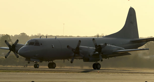
A Royal Australian Air Force P-3 Orion taxies along the tarmac at RAAF Base Pearce as it arrives back from the on-going search operations for missing Malaysia Airlines Flight MH370 in Perth, Australia, Tuesday, April 8, 2014. AP
PERTH – A fleet of ships and planes pursued Wednesday the hunt for elusive signals and debris from missing Malaysian Flight MH370, scouring tens of thousands of square kilometers of remote Indian Ocean, officials said.
It is more than a month since the Boeing 777 vanished with 239 people on board and time is running out to detect further signals as the batteries in beacons on the jet’s black box data recorders reach their expiry date.
Searchers are trying to detect more “pings” from below the waves and have pledged to spend several more days trying to pinpoint the crash site before a mini-sub is launched to comb the seabed.
“Up to 11 military aircraft, four civil aircraft and 14 ships will assist in today’s search,” over a zone covering 75,423 square kilometers (29,000 square miles), Australia’s Joint Agency Coordination Center (JACC) said.
The focus of the search area is 2,260 kilometers (1,400 miles) northwest of Perth and JACC said scattered showers were forecast for Wednesday.
JACC chief Angus Houston explained Tuesday that a submersible sonar device would not be launched to comb the seabed until it was clear batteries that may be emitting pings from the blackboxes had expired.
“We need to continue (listening) for several days to the point at which there is absolutely no doubt that the pinger batteries will have expired,” Houston said.
He has labeled “very encouraging” signals picked up earlier this week by a specialized US Navy device towed deep underwater by the Australian vessel Ocean Shield.
If the transmissions can be recaptured and confirmed as emanating from the Malaysia Airlines plane’s data recorders, technicians are poised to deploy a submersible drone, the Bluefin-21, far off western Australia.
The US-made device uses sonar to scan the seafloor for possible crash debris.
‘Very painstaking work’
The plane mysteriously vanished March 8, diverting en route from Kuala Lumpur to Beijing for reasons unknown. The search is focused on a 600-kilometer arc of the remote southern Indian Ocean.
The Ocean Shield is criss-crossing an area where satellite data indicates the plane may have gone down, trying to home in on the signals.
“If we go down there now and do the visual search it will take many, many, many days because it’s very slow, very painstaking work to scour the ocean floor,” Houston said.
If the Bluefin-21 detects something, it can resurface and be sent back down with a video camera to seek visual evidence of a crash.
However, the 4.5-kilometer (nearly three-mile) depth of the ocean floor is the absolute operating limit for a Bluefin-21, which is designed for deep-sea surveying.
Ocean Shield, which earlier picked up two series of pulses, one lasting two hours and 20 minutes and the other 13 minutes, is operating at the northern end of the defined search area, JACC said.
The Chinese ship Haixun 01 and Britain’s HMS Echo are working the southern end.
Gerry Soejatman, an independent aviation analyst based in Jakarta, said if a crash site cannot be pinpointed, underwater sonar mapping can take an entire day for an area the size of a football field, and possibly “a month, or maybe more,” for a one-square-kilometer section.
“It is crucial to find the location where the signal is coming from. Time is running out. If the signal stops, it will be a much harder task,” he said.

