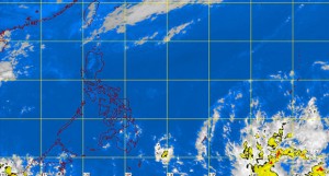
MANILA, Philippines—The low pressure area threatening to enter the Philippine area of responsibility intensified into a tropical depression, the state weather bureau said Friday.
It remained over the Pacific and was forecast to enter the PAR by Sunday or Monday, Fernando Cada of the Philippine Atmospheric Geophysical and Astronomical Services Administration told INQUIRER.net.
If it enters PAR, it will be locally named “Domeng.”
The tropical depression was forecast to make landfall by Wednesday or Thursday.
Cada said it could still intensify in the coming days as it remained at sea, although it could also weaken.
“All weather disturbance is a cause to worry but what is important is the preparation of the local government and coordination,” he said.
The National Disaster Risk Reduction and Management Council said the direction of the tropical depression is the same as the path of typhoons Yolanda (Haiyan) and Pablo (Bopha).
Yolanda devastated Eastern Visayas in 2013, while Pablo wreaked havoc in Davao region in 2012. Both strengthened into a typhoon before it entered the PAR.
“Well, let’s hope it’s just a tropical depression,” NDRRMC Executive Director Eduardo del Rosario told reporters.
The NDRRMC will alert local disaster agencies by Saturday, he said.
While it is a dry season, up to one cyclone is forecast to enter the country this month.
RELATED STORY
Weather bulletins hard to grasp–survey
