Weather’s fine but storm still nearby
Metro Manila and the rest of the country had relatively fair weather on Monday.
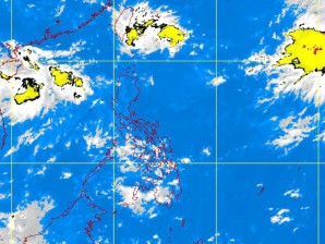
Part of the reason: The tropical depression hovering over the East Philippine Sea did not swirl into the Philippine area of responsibility (PAR) Sunday night as the weather bureau had forecast.
After moving at a fast clip, the depression (“Onyok”) suddenly slowed and became nearly stationary close to the PAR, according to the Philippine Atmospheric, Geophysical and Astronomical Services Administration (Pagasa).
“Two high pressure areas, one over the north Pacific Ocean and the other over the Visayas and Mindanao, prevented it from coming in,” said forecaster Aldczar Aurelio. “Just imagine it is caught between two large rocks.”
Moving westward at 5 kph from a high of 20 kph, the depression was now forecast to break through the PAR either Monday afternoon or evening instead, Aurelio said.
Article continues after this advertisementForecasters, including Pagasa Supervising Undersecretary Graciano Yumul, had predicted that Onyok would enter the country at 11 p.m. on Sunday, but on Monday everyone awoke to clear skies. It rained on Monday afternoon, however, in the metropolis.
“That’s a scenario. We had actual data and analyzed it, and made our forecast based on this,” Aurelio said to explain the earlier forecast. “We’re not God who can accurately predict when a storm is coming in. The good thing is, the public knows we have a depression.”
