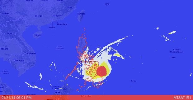
MANILA, Philippines—More areas were placed under storm signals even as Tropical Storm “Basyang” (international name Kajiki) slightly weakened late Friday.
“Basyang” now packed maximum sustained winds of 65 kilometers per hour near the center and gusts of up to kph. It moved faster at 39 kph westward, the Philippine Atmospheric Geophysical and Astronomical Services Administration said.
The storm made its first landfall over Siargao Island at 6p.m. It made five landfalls and was last spotted over Ubay, Bohol as it approached Cebu.
Storm signals were placed in the following areas:
Signal No. 2 (winds with 60-100 kph)
Northern Palawan
Calamian Group of Islands
Aklan
Antique
Capiz
Iloilo
Guimaras
Negros Oriental
Negros Occidental
Siquijor
Cebu
Camotes Island
Bohol
Leyte
Southern Leyte
Biliran Province
Samar
Eastern Samar Camiguin
Dinagat Province
Surigao del Norte
Siargao Is.
Northern Part of Surigao del Sur
Northern Part of Agusan del Norte
Signal No. 1
Rest of Palawan
Occidental Mindoro
Oriental Mindoro
Romblon
Masbate
Ticao Island Northern Samar Misamis Oriental
Misamis Occidental
rest of Agusan del Norte
rest of Surigao del Sur
Agusan del Sur
Northern part of Bukidnon
Residents in areas under storm signals were alerted against possible flash floods and landslides. Those living in coastal areas under storm Signal No. 2 were alerted of storm surges.
Basyang was forecast to exit the Philippine area of responsibility on Sunday morning.
As with previous updates on Basyang, fishing boats and other small seacraft are still advised not to venture out into the eastern seaboard of Central Luzon and the eastern and southern seaboards of Southern Luzon due to the surge of northeast monsoon.
RELATED STORY
‘Basyang’ makes landfall over Siargao island
