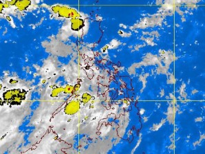
Typhoon brewing, not yet threat to Philippines
A potentially potent storm is brewing in the Pacific but current weather models showed that it would spare the Philippines, the state weather agency said.
The Philippine Atmospheric, Geophysical and Astronomical Services Administration (Pagasa) on Friday said the new weather disturbance was spotted 2,500 kilometers east of Batanes and was swirling northwest to the Taiwan-Japan area.
As of Friday afternoon, Pagasa had yet to categorize the low pressure area as it had not entered the country’s territory. The Japan Meteorological Agency, however, classified it as a tropical depression.
‘Onyok’
Should it enter the Philippine Area of Responsibility, or PAR, on Sunday, as some models predict, it would be named “Onyok.”
Article continues after this advertisementAlthough the weather disturbance was still too far to affect the Philippines, the agency was closely monitoring it as it could intensify in the next days, Ricky Fabregas, a Pagasa forecaster, said.
Article continues after this advertisementFabregas said it was possible that it would get stronger. “It is still over water. That is where it gets its life,” he said.
Science Undersecretary Graciano Yumul said it was “always possible” that the weather disturbance could develop into a typhoon as “it is still above water.”
23 to 37 kph
The Hawaii-based Joint Typhoon Warning Center (JTWC) of the United States said the weather disturbance’s maximum sustained winds had been measured at 15-20 knots (23-37 kph).
“The potential for the development of a significant tropical cyclone within the next 24 hours remains medium,” the JTWC said.
Although the new tropical disturbance is heading west to East Asia, it might spare the Philippines, especially the already storm-battered Luzon from damage, forecasters said.
They said there was a good chance that the Philippines, many areas of which were battered by Supertyphoon “Mina” two weeks ago, would get a respite from stormy weather.
Mina, which hit north Luzon on August 27, killed at least 30 people and destroyed P1 billion worth of crops and infrastructure. The cyclone, which had maximum sustained winds of up to 200 kph, was the strongest typhoon yet to hit the country in 2011.
Current forecast models indicated that the tropical disturbance in the Pacific, while it could hit the Philippines’ boundary, was unlikely to make landfall in the Philippines, Pagasa chief forecaster Robert Sawi said.
Like ‘Nonoy’
Sawi explained that the disturbance had formed too far up north, in about the same latitude where Batanes province is located.
Thus, if it continued to move in the northwest direction, the weather disturbance would head toward Taiwan, forecasters said.
“It might be like ‘Nonoy,’” Fabregas said, referring to the storm that breached the country’s boundary on Thursday morning. By Thursday afternoon, the cyclone had exited the Philippine area of responsibility.
Rains over Metro
Still, residents of Metro Manila and western Luzon were warned to prepare for light to moderate rains in the weekend, Pagasa said.
But the rains would not be coming from the cyclone, which was still too far to bring foul weather to the Philippines, Pagasa officials said.
The rains and thunderstorms that lashed Metro Manila and provinces on the western coast of Luzon Friday will continue through Sunday, they said.
The downpours were brought by the Intertropical Convergence Zone (ITCZ) and a shallow low pressure area off the coast of Catanduanes, the weather bureau noted.
Pagasa said it was keeping an eye on the low pressure area as it could grow stronger over the weekend.
Due to the ITCZ and the shallow low pressure area, Sawi said the rains and thunderstorms would persist in the “next three days.” Rains and thunderstorms will be experienced in Sourthern Luzon, Visayas and Mindanao, he said.
