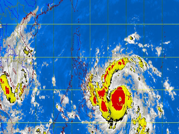
MT Satellite image November 7, 2013, Thursday, 5:30 AM. Screengrab from https://www.pagasa.dost.gov.ph/
MANILA, Philippines—Storm signal No. 2 was hoisted over seven areas in the Visayas and Mindanao as Supertyphoon “Yolanda” (international name: Haiyan) gained more strength, packing maximum sustained winds of 215 kilometers per hour as of 4 a.m. (from the previous 195 kilometers) near the center and gustiness of up to 250 kph (from 230 kph).
According to the Philippine Atmospheric Geophysical and Astronomical Services Administration (Pagasa), Yolanda is forecast to move rapidly west northwest-ward at 30 kph toward eastern Visayas.
Under signal 2 are: Eastern Samar, Samar and Southern Leyte provinces in the Visayas and Surigao del Norte (including Siargao Island), Dinagat Island, northern part of Surigao del Sur and northern part of Agusan del Norte.
Placed under signal No. 1 are: Camarines Norte, Camarines Sur, Catanduanes, Albay, Sorsogon, Ticao Island, Burias Island, Masbate, Romblon, Marinduque and southern Quezon in Luzon;
Aklan, Capiz, Iloilo, Antique, Guimaras, Negros Occidental and Oriental, Cebu, Camotes Island, Bohol, Siquijor, Leyte, Biliran Island and Northern Samar in Visayas; and
Camiguin; Misamis Oriental; rest of Agusan del Norte, Agusan del Sur; and rest of Surigao del Sur, in Mindanao.
Yolanda is expected to be 240 kilometers east southeast of Guiuan, Eastern Samar, by Friday morning and in the vicinity of Romblon island by Saturday morning.
By Sunday morning, according to Pagasa, it is expected to be 740 km west northwest of Coron, Palawan.
Yolanda will bring heavy rains within a wide 600-kilometer diameter. It is forecast to make landfall over Eastern Visayas on Friday.
Pagasa said sea travel is risky over the northern and eastern seaboards of northern Luzon and over the eastern seaboard of Central Luzon.—Rick Alberto
RELATED STORY:
Storm signal 1 hoisted over 13 areas in Visayas, Mindanao

