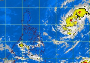
MANILA, Philippines—A tropical depression expected to be named “Vinta” once it enters the Philippine area of responsibility (PAR) on Tuesday is not foreseen to be a threat as it will be too far to directly affect any part of the country.
But the Philippine Atmospheric, Geophysical and Astronomical Services Administration (Pagasa) forecasters said the intertropical convergence zone (ITCZ) is expected to continue bringing light to moderate rains over Palawan, portions of the Visayas and Mindanao.
Forecaster Buddy Javier said that as of 4 p.m. Monday, the tropical depression is at 1,380 kilometers east of the Visayas, with maximum sustained winds of 45 kilometers per hour.
Javier told the Inquirer that Vinta is moving northwest at a speed of 20 kph.
“Based on our analysis of its current track, it could possibly make landfall somewhere in northern Luzon but it is currently too far to immediately affect any part of the country,” he said.
The forecaster added that the tropical cyclone could still intensify into a tropical storm while it draws nearer as it remains over the Pacific Ocean.
According to the Japan Meteorological Agency (JMA), as of 12 a.m. UTC (Universal Coordinated Time) Monday, the tropical depression had maximum sustained winds of 55 kph and gustiness of 83 kph.
The JMA forecasts the tropical depression to change to a west-northwest direction by 12 a.m. UTC Tuesday and gain strength at a maximum wind speed of 65 kph and gustiness of 92 kph.
In Pagasa’s forecast for Tuesday, Palawan, the eastern Visayas and Mindanao will have cloudy skies with light to moderate rainshowers and thunderstorms caused by the prevailing ITCZ while Metro Manila, Central Luzon as well as the Ilocos, Cordillera and Cagayan Valley regions are expected to have partly cloudy to cloudy skies with isolated light rains.
RELATED STORY:
Tropical depression may enter PH Tuesday – Pagasa
