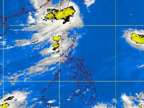
Typhoon “Mina” which pummeled northern Luzon with heavy rains and gusty winds of almost super-typhoon intensity was very similar to Hurricane “Irene” which left a trail of destruction in the Caribbean and the United States East Coast, according to a weather forecaster.
“At their peak, both Irene and Mina had nearly the same intensity. They dumped heavy rains and triggered flooding,” said Rene Paciente, Pagasa assistant weather services chief.
But, of course, there was less hype about Mina (international codename Nanmadol) on CNN and BBC since it struck a little known country in the Asia-Pacific, unlike Irene which slammed highly urban cities in the US, Paciente said.
Storms originating from the Pacific Ocean are called tropical cyclones, while those emerging from the Atlantic Ocean are referred to as hurricanes, Paciente said.
Same cyclone category
So Irene and Mina belong to the same category of cyclone, he said.
Before and after hitting the tip of Cagayan in northern Luzon on Saturday morning, Mina was packing maximum winds of 195 kilometers per hour, just short of the 210kph intensity of a supertyphoon.
It dumped heavy rains, triggered landslides, felled trees and electric posts making national highways impassable, and spawned huge waves on the western coasts of Luzon.
Irene had winds of 137 kph when it slammed into the coast of North Carolina last Saturday before tearing into New York, shutting down airports, transit systems and businesses, and causing massive power blackouts.
Before Mina and Irene made landfall on the same day, a Pagasa weather forecaster said in jest: “We’re monitoring two storms.”
Most powerful
Forecasters agreed that Mina was the most powerful typhoon to cross the archipelago this year.
In its aftermath, at least 14 people—including five people buried alive in a dumpsite in Baguio City—were reported killed, some 221,061 people displaced, and P1 billion worth of agricultural crops destroyed.
Because of the heavy damage it inflicted on crops and infrastructure, and the large number of casualties, Mina will be stricken off the Philippine Atmospheric Geophysical and Astronomical Services Administration’s list of cyclone names.
The criterion for delisting is either damage to crops and infrastructure of at least P1 billion or casualties numbering at least 300, Paciente said.
Pagasa tracked Mina for at least seven days after it intensified into a tropical depression. The weather bureau found it one of the most difficult weather disturbance to monitor because of its “erratic behavior.”
Mina swirled over the Philippine Sea far from the archipelago, and wasn’t expected to make landfall until Saturday.
Because of its “interaction” with a storm (international codename: Talas) hovering some 1,100 km away over the Pacific Ocean, Mina slowed down and changed direction a number of times.
Erratic behaviour
“It’s unusual because if you’re a strong cyclone you behave well. But because of its interaction with Talas, it behaved erratically,” Paciente said.
Mina left the Philippine area of responsibility on Monday, heralding better weather in Luzon and the rest of the country.
As reports of the destruction of crop lands continue to trickle in from the regions, the Department of Agriculture fears the value of the damaged crops would be higher than the P1 billion earlier estimated as many provinces in Central Luzon had yet to submit their reports.
Rice lands sustained the most damage at P663 million, while the corn sector lost P397 million worth of crops.
About 36,293 hectares of rice paddies were flattened or drowned, the DA said. Of that area, 124 hectares were completely destroyed.
Planting stage
DA spokesperson Salvador Salacup said some provinces like Cagayan Valley and Isabela may be able to recover their palay losses. “They were still at the planting stage because they started late. So maybe they can still replant,” he said.
Agriculture Secretary Proceso Alcala is concerned that the storms expected in the latter part of the year could wipe out agriculture’s gains in the first semester. With Kristine L. Alave


