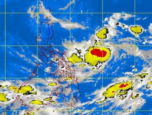
MANILA, Philippines—A low pressure area (LPA) spotted east of the Philippines is expected to develop into a tropical cyclone and strike the country’s northern section a day or two, the weather bureau said Tuesday.
The LPA will be given the local name “Santi” once it intensifies into a tropical depression or storm in the country’s area of responsibility, the Philippine Atmospheric, Geophysical and Astronomical Services Administration (Pagasa) said.
As of Tuesday morning, the LPA was tracked 1,000 kilometers east of Virac, Catanduanes.
“There’s a high likelihood that it will develop into a tropical cyclone within 24 to 48 hours,” Pagasa forecaster Glaiza Escullar said.
She said the weather disturbance would likely move toward the northernmost areas of Luzon, either grazing or making landfall in Cagayan.
Meanwhile, the intertropical convergence zone (ITCZ) is affecting the Visayas and Mindanao, bringing rain.
Based on Pagasa’s 24-hour weather outlook, the Visayas and Mindanao will have cloudy skies with light to moderate rain showers and thunderstorms.
Metro Manila and the rest of the country will be partly cloudy to cloudy with isolated rain showers or thunderstorms mostly in the afternoon or evening.
Escullar said the southwest monsoon, or “habagat,” still prevailed over the Philippines, but was very weak. It may be enhanced by the coming tropical cyclone, she added.
The transition to the northeast monsoon, or “amihan,” signaling the start of the cold months, will probably begin in the third to fourth week of October, Escullar said.—DJ Yap
