‘Quedan’ now a typhoon but won’t affect PH–Pagasa
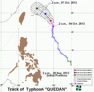
MANILA, Philippines — “Quedan” (international name Fitow) intensified into a typhoon on Friday as it hovered over extreme Northern Luzon.
It is not expected, however, to affect the country, Philippine Atmospheric Geophysical and Astronomical Services Administration’s weather forecaster Aldczar Aurelio told INQUIRER.net.
He also noted that the southwest monsoon is weakening. It will likely prevail until mid- October before it shifts to northeast monsoon or “hanging amihan.”
The typhoon was last observed 720 kilometers east-northeast of Itbayat, Batanes, packing maximum sustained winds of 120 kilometers per hour near the center and gusts of up to 150 kph.
It was moving slowly north at 7 kph.
Article continues after this advertisement“Bicol Region, Palawan, Visayas and Zamboanga Peninsula will have cloudy skies with light to moderate rainshowers and thunderstorms. Metro Manila and the rest of the country will be partly cloudy to cloudy with isolated rainshowers or thunderstorms mostly in the afternoon or evening,” Pagasa said.
Sea travel is risky over the northern and eastern seaboard of Northern Luzon and the eastern seaboard of Central Luzon.
