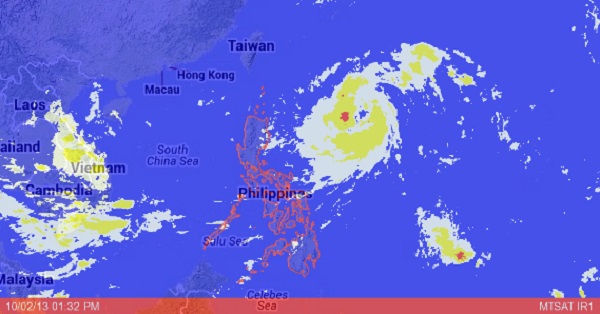
MANILA, Philippines—Tropical Storm Quedan continued to gain strength east of the Philippines on Wednesday but it was not expected to affect any part of the country directly, the state weather bureau said.
The Philippine Atmospheric, Geophysical and Astronomical Services Administration noted that the storm had intensified as it moved over the Philippine Sea.
As of mid-Wednesday, the storm was some 790 kilometers east of Tuguegarao City.
It was packing winds of 95 kilometers per hour near the center and gusting up to 120 kph, Pagasa said. It was moving northward at 17 kph.
In an advisory, Pagasa said it expected the storm to leave the Philippine area of responsibility on Saturday morning, by which time it would be 770 kilometers northeast of Itbayat, Batanes, or 580 kilometers east of northern Taiwan.
According to Pagasa’s 24-hour outlook, Quezon province, Bicol region, Visayas and Mindanao will have cloudy skies with light to moderate rain showers and thunderstorms.
Metro Manila and the rest of Luzon will be partly cloudy to cloudy with isolated rain showers or thunderstorms, it added.
