‘Quedan’ staying a while; it’s ITCZ bringing the rain
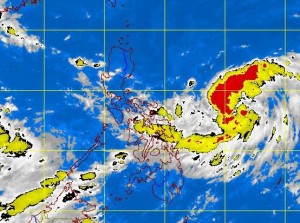
MANILA, Philippines—Tropical Depression “Quedan” has shown signs of lingering within the Philippine area of responsibility (PAR) but the weather bureau anticipates it would continue to keep its distance from the country.
Philippine Atmospheric, Geophysical and Astronomical Services Administration (Pagasa) forecasters said that while Quedan will have no direct effect on the country because of its distance, the intertropical convergence zone (ITCZ) is expected to bring rain to some areas.
The ITCZ results from the convergence of trade winds from the northern and southern hemispheres.
Forecaster Samuel Duran said that generally good weather would prevail over Metro Manila and other areas previously hit by rains spawned by the enhanced hanging habagat (southwest monsoon) beginning Tuesday.
Duran said that at 4 p.m. Monday, Quedan was estimated at 790 kilometers east of Guiuan, Eastern Samar, with maximum sustained winds of 55 kilometers per hour near the center and moving north at 7 kph.
Article continues after this advertisementEstimated rainfall is from 5 to 7.5 millimeters per hour or moderate to occasionally heavy within the 300-km diameter of the cyclone.
Article continues after this advertisementThe weather forecaster said that although Quedan was previously forecast to exit the PAR on Tuesday afternoon, its movement had grown sluggish since Sunday night and it slightly changed direction from north-northwest to north.
Based on its current track, by Tuesday morning Quedan is expected to be 900 kilometers east of Virac, Catanduanes, and 1,150 km east of Baler, Aurora, by Wednesday morning. By Thursday morning, the tropical depression is anticipated to be 1,190 km east of Tuguegarao City.—Jeannette I. Andrade
