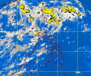
MANILA, Philippines—A low-pressure area spotted east of the Philippines has moved closer to Luzon, bringing rains and thunderstorms over the island’s northern and central regions, the state weather bureau said on Friday.
At midday Friday, the low pressure area, which was embedded in the monsoon trough, was located 210 kilometers east of Baler, Aurora, the Philippine Atmospheric, Geophysical and Astronomical Services Administration (Pagasa) said.
The LPA and monsoon trough would bring light to moderate rains and thunderstorms to Northern and Central Luzon, Pagasa said in an advisory.
A monsoon trough is a region of low atmospheric pressure at sea level that typically brings cloudiness and rains.
Pagasa forecaster Fernando Cada said there was only a slim chance the LPA would develop into a tropical cyclone, but would bring cloudy skies and scattered rains to many parts of Luzon until the weekend.
According Pagasa’s 24-hour weather outlook, Cagayan Valley will experience cloudy skies with moderate to occasionally heavy rains and thunderstorms that could trigger floods and landslides.
Metro Manila and the rest of Luzon would have cloudy skies with light to moderate rain showers and thunderstorms, it said.
Visayas and Mindanao would be partly cloudy to cloudy with isolated rains or thunderstorms, Pagasa said.
Light to moderate winds blowing from the west to southwest would prevail over Palawan, Visayas and Mindanao, and winds coming from the northeast to northwest over the rest of Luzon. Coastal waters throughout the archipelago will be slight to moderate, Pagasa said.
