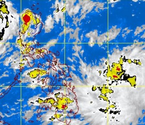
Satellite Image as of 3:32 p.m., 10 September 2013. Image from pagasa.gov.ph
MANILA, Philippines—A new low-pressure area is seen entering the Philippine area of responsibility in two days but it remains to be seen if it will hit land, the state weather bureau said on Tuesday.
As of mid-Tuesday, the low pressure area was observed 1,080 kilometers east of Northern Mindanao, the Philippine Atmospheric Geophysical and Astronomical Services Administration (Pagasa) said.
Pagasa weather forecasting section chief Rene Paciente said the weather system’s track appeared to curve upward and, according to three out of four models, would not make landfall.
But there is still a chance it would hit land, likely through Northern or Central Luzon, he told reporters.
Paciente added that the low pressure area had the potential of turning into a tropical cyclone for as long as it was still over the ocean.
According to Pagasa’s 24-hour weather outlook, the low pressure area would bring cloudy skies with light to moderate rains and thunderstorms to Eastern Visayas and Eastern Mindanao.
Palawan, Visayas and Mindanao are forecast to experience cloudy skies with light to moderate rain showers and thunderstorms.
Metro Manila and the rest of the country will have partly cloudy to cloudy skies with isolated rain showers or thunderstorms, Pagasa said.
Paciente said the capital would experience good weather in the next few days except for isolated thunderstorms usually between 1 p.m. and 6 p.m.
Moderate to occasionally strong winds blowing from the east will prevail over extreme Northern Luzon and its coastal waters will be moderate to occasionally rough, Pagasa said.
Elsewhere, winds will be light to moderate coming from the southwest to southeast with slight to moderate seas, it said.