


Signal No. 4 up over Cagayan as N. Luzon braces for ‘Mina’
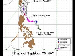
PAGASA Track as of 5 p.m., 26 August 2011
MANILA, Philippines – Signal no. 4 has been raised over parts of Cagayan as Typhoon “Mina” (international name: NANMADOL) intensified further and moved closer to Northern Luzon, the Philippine Atmospheric, Geophysical and Astronomical Services Administration (Pagasa) said Friday.
In its latest bulletin, Pagasa said that Mina was seen 150 kilometers northeast of Casiguran, Aurora and was packing maximum sustained winds of 195 kilometers per hour near the center and gusts of up to 230 kph.
Mina is forecast to move northwestward at 9 kph.
Signal No. 3 remains raised over Isabela, Rest of Cagayan, Calayan, Babuyan Group of Island and Batanes Group of Island while Signal No. 2 is up over Northern Aurora, Quirino, Ifugao, Mt. Province, Kalinga and Apayao.
Meanwhile, Signal No. 1 is up over Nueva Vizcaya, Benguet, Ilocos Sur, Ilocos Norte, Abra and the rest of Aurora, Pagasa said.
“Residents in low-lying and mountainous areas under Public Storm Warning Signals, Southern Luzon and Visayas are alerted against possible flashfloods and landslides. Likewise, those living in coastal areas are alerted against big waves or storm surges generated by this tropical cyclone,” Pagasa said.
Estimated rainfall amount is from 15 to 25 millimeters per hour within the 600- kilometer diameter of Mina. The typhoon is also forecast to enhance the southwest monsoon, Pagasa said.
Southern Luzon and the Western sections of Central Luzon, Visayas and Mindanao will experience monsoon rains becoming widespread rains over Coron, Mindoro and Western Visayas which may trigger flashfloods and landslides.
Meanwhile, the rest of the country will be mostly cloudy with scattered rainshowers and thunderstorms.
By Saturday afternoon, Mina is forecast to move 150 km northeast of Tuguegarao City and 50 km north of Basco, Batanes by Sunday afternoon. By Monday afternoon, Mina is forecast to be at 250 km north of Basco, Batanes.


