

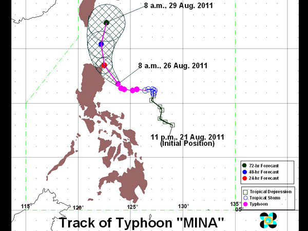
PAGASA Track as of 8 a.m., 26 August 2011
MANILA, Philippines—Signal number 3 has been raised over several provinces even as typhoon Mina (international name: NANMADOL) maintained its strength as it continued to move westward, the Philippine Atmospheric, Geophysical and Astronomical Services Administration (Pagasa) said.
In its latest weather bulletin, Pagasa said that Mina was seen, as of 10 pm at 190 km east of Casiguran, Aurora and was still packing maximum sustained winds of 140 kilometers per hour near the center and gusts of up to 10- kph. Mina was forecast to move westward at 13 kph, Pagasa said.
Signal number 3 has been raised over Isabela, Cagayan and Northern Aurora. Signal number 2 remains raised over Batanes, Calayan, Babuyan group of island, Apayao, Kalinga, Quirino and the rest of Aurora while signal number 1 is still hoisted over Ilocos Norte, Abra, Ilocos Sur, Mt. Province, Benguet, Ifugao, Nueva Vizcaya and Nueva Ecija.
Mina was expected to enhance the southwest monsoon and bring rains to parts of Southern Luzon and Visayas, Pagasa said.
“Estimated rainfall amount is from 15-25 mm per hour within the 500 km diameter of the typhoon,” Pagasa said.
Residents in low lying and mountainous areas having storm signals, and sections of Southern Luzon and Visayas experiencing monsoon rains have been warned to take precaution against possible flash floods and landslides. Likewise, those living along coastal areas were alerted against storm surges, which may be generated by the typhoon, the state-run weather bureau said.
By Friday evening, Mina was expected to be 140 km northeast of Aparri, Cagayan and by Saturday evening, Mina was forecast 200 km north northeast of Basco, Batanes. Mina was expected to be 500 km north northeast of Basco, Batanes or 320 km west southwest of Okinawa, Japan by Sunday evening, Pagasa said.
Original posted: 12:01 am | Friday, August 26th, 2011

