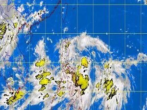
MANILA, Philippines – Tropical depression “Nando” moved closer to Aurora Monday morning as it continued to move north-northwest, the state weather bureau said.
The cyclone was last observed 560 kilometers east of Baler, Aurora, packing maximum sustained winds of 55 kilometers per hour near the center, the Philippine Atmospheric Geophysical and Astronomical Services Administration said. It is forecast to move north-northwest at 15 kilometers per hour.
Ben Oris of Pagasa told INQUIRER.net that the cyclone was not expected to make landfall.
Cloudy skies with moderate to heavy rainshowers and thunderstorms which may trigger flashfloods and landslides are seen over the Bicol region, Calabarzon and the province of Aurora.
Nando is expected to exit the Philippine area of responsibility by Thursday.
Meanwhile, Metro Manila and the provinces of Quirino, Isabela and Nueva Vizcaya, the rest of Central Luzon, MIMAROPA, Visayas, Zamboanga Peninsula, Caraga and Northern Mindanao will have cloudy skies with light to moderate rainshowers and thunderstorms, Pagasa said.
The rest of the country will be partly cloudy to cloudy with isolated rainshowers or thunderstorms.
Moderate to occasionally strong winds blowing from the northeast to northwest will prevail over the eastern section of Northern and Central Luzon and coming from the southwest to west over the rest of the country. The coastal waters throughout the archipelago will be moderate to occasionally rough, Pagasa also said.
Related Stories:
LPA develops into tropical depression ‘Nando’


