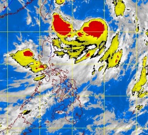
MANILA, Philippines—Tropical storm Maring (international nam: Trami) intensified further and, worse, remained almost stationary, the state weather bureau said early Tuesday.
The storm, packing maximum sustained winds of 95 kilometers per hour and gusts of up to 120 kph, was tracked to move north at a slow pace of 11 kph..
It was last observed 600 kilometers east of Itbayat, Batanes.
The Philippine Atmospheric Geophysical and Astronomical Services Administration said Maring is expected to exit the Philippine area of responsibility Wednesday evening or early Thursday, according to Pagasa.
The southwest monsoon, meanwhile, continued to affect Luzon and Visayas.
“The whole of Luzon and Western Visayas will experience monsoon rains, which may trigger flashfloods and landslides. The rest of Visayas will have cloudy skies with light to moderate rainshowers and thunderstorms. Mindanao will be partly cloudy to cloudy with isolated rainshowers or thunderstorms,” Pagasa said.
Moderate to strong winds blowing from the southwest will prevail throughout the archipelago and the coastal waters will be moderate to rough, it added.
